![]() A menudo un sitio de arte rupestre tiene una característica muy específica que además es a menudo único en ese sitio. Este artículo presenta un elemento tan distintivo en el sitio rupestre de Chuquillanqui en la cuenca del Río Chicama en el norte de Perú.
A menudo un sitio de arte rupestre tiene una característica muy específica que además es a menudo único en ese sitio. Este artículo presenta un elemento tan distintivo en el sitio rupestre de Chuquillanqui en la cuenca del Río Chicama en el norte de Perú.
Often a rock art site has a very specific feature that moreover is often unique to that site. This paper presents such a distinguishing element at the petroglyph site of Chuquillanqui in the Chicama drainage of northern Peru.
by Maarten van Hoek
*
![]() *
*
Los Bordes Aserrados de las Rocas de Chuquillanqui, Perú
Por Maarten van Hoek – rockart@home.nl
![]() English Version Available Below
English Version Available Below
Ver mi video sobre Chuquillanqui (en Español)
![]()
Introducción
Aunque poco conocido, el sitio rupestre de Chuquillanqui alberga una de las concentraciones más importantes de arte rupestre al oeste de los Andes. En realidad el sitio comprende al menos dos diferentes grupos de petroglifos: Cerro el Diablo y (de 1256 m al sur) Quebrada de Algarrobos. Los dos grupos están separados por la extensa planicie de las Pampas de Cardonal (ligeramente inclinada al NO), llena de un impresionante bosque de enormes cactáceas conocido como ‘cardos’ o ‘gigantones’ (Neoraimondia macrostibas), que a veces son tan altas como 15 m. Junto con el sitio rupestre de Alto de la Guitarra (en Virú), Chuquillanqui es uno de los sitios más impresionantes que he visitado en el América del Sur. Para mi es un sitio casi mágico.
El complejo está situado en la parta alta del Río Chicama (Figura 1), unos 77 km hacia el interior (en línea recta) a una altitud promedio de alrededor de 850 m. El área es limitada por el norte con el Río Chuquillanqui y al oeste por el Río Huancay. Desde ciertos puntos en ambos sitios se puede ver la confluencia de estos dos ríos. Ellos vínculo cerca del caserío de El Tambo y desde aqui forman el Río Chicama que a su vez se une con el Océano Pacífico, 89 kilometros más al SO. El complejo está situado en un paisaje más espectacular enmarcada por imponentes montañas. Directamente al sur es la escarpada pared de una cadena de montañas formadas por (de oeste a este) Cerro Malín, Cerro Colorado y Cerro Carangas (Figura 2). Al SO, a través del Río Huancay es la aún más alta cadena de montañas de Cerro Luanga. Al este se encuentra el Cerro Negro y al norte los picos del Cerro Chin Chin dominan el horizonte. Al oeste se puede ver el pico del Cerro la Carcel y sus estribaciones extremos al sur del valle del Río Chicama.

Figura 1. Ubicación de Chuquillanqui y otros sitios de arte rupestre en la cuenca del Río Chicama. Mapa © de Maarten van Hoek, basado en Google Earth.

Figura 2. Ubicación del sitio rupestre de Quebrada de Algarrobos. Fotografía © por Maarten van Hoek.
![]() Antecedentes
Antecedentes
Parece que el explorador alemán Hans Dieter Disselhoff fue el primero en mencionar el arte rupestre en Chuquillanqui (1955: 55-60). Después de un silencio de más de 20 años el arqueólogo Luis Rodríguez López publicó un librete sobre el arte rupestre en Chuquillanqui (1976). Aunque la información muy útil en relación con el fondo, el librete ofrece muy poco en términos de descripción de los petroglifos. Además, sólo se incluyeron ocho fotos de paneles de arte rupestre y seis dibujos. Rainer Hostnig incluido Chuquillanqui en su Inventario Nacional (2003: 202 y 215), junto con dos ilustraciones tomadas del librete de Rodríguez López (1976) y dos fotos proporcionadas por Daniel Castillo. En 1991 Rodríguez López publicó un artículo más sobre Chuquillanqui y en 2006 Rodríguez López, junto con el arqueólogo Daniel Castillo Benites, presentaron una ponencia en el II Simposio Nacional de Arte Rupestre (Trujillo), de los cuales el texto muy corto con 19 fotos sin numeración y uno mapa una vez estaba disponible a través de Internet. Parece que hasta 2005 no se hizo ningún intento de separar las imágenes en Cerro el Diablo y la Quebrada de Algarrobos en cualquier publicación.
Sin embargo, el registro más extensivo sobre Chuquillanqui fue publicado en 2006 por Daniel Castillo Benites (2006: 77-93). Castillo incluye muchos dibujos en blanco y negro de muchos petroglifos (2006: 174-283). A pesar de que separa claramente las descripciones y las ilustraciones de los dos sitios (Cerro el Diablo y Quebrada de Algarrobos), sus dibujos – aunque muy útil – no siempre son fiables. Hay varios dibujos en los que algunos petroglifos no aparecen o están incorrectamente dibujados, como su Fig. 213 (Figura 3). También es cierto que algunos de sus dibujos han reflejados (sin querer) horizontalmente (como su fig. 271), giradas (como sus figuras 237 y 266) o que los petroglifos de un panel o bloque se han incluido como dos diferentes paneles y ilustraciones separadas, incorrectamente dando la impresión de que se trata de dos paneles diferentes (como sus dibujos en las figuras 23 y 27; 160 y 161). Por último, Castillo no siempre agrupa dibujos que se encuentran en los paneles vecinos, como sus figuras 246, 263, 262, 255 y 248; ver Van Hoek 2016a).
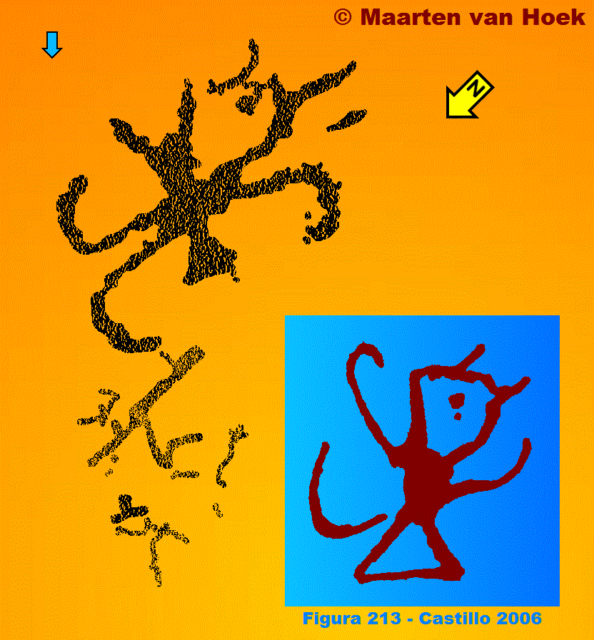
Figura 3. Petroglifos en un panel de roca en Cerro el Diablo. Dibujo © por Maarten van Hoek. Inserto azul: el mismo panel dibujado por el arqueólogo Daniel Castillo Benites (2006: Fig. 213).
Por último, aunque Castillo incluye un gran número de dibujos de los paneles con petroglifos que él registró en Chuquillanqui, es cierto que su registro sólo representa una impresión de lo que está disponible. Castillo incluye 110 ilustraciones de ‘paneles’ con arte rupestre en su sección de Chuquillanqui (2006: 77-93). Sin embargo, es un problema que especialmente en Chuquillanqui es extremadamente difícil distinguir entre los paneles. Las rocas en ambos grupos – que comprenden afloramientos y bloques – son mucho más fragmentado y, lo que es más, petroglifos a menudo continúan en diferentes paneles. El uso del término ‘Panel’, también en mi registro, por lo tanto, es bastante ambiguo. Rodríguez López (1976: 26) menciona la existencia de 298 ‘petroglifos’ en los dos sitios de Chuquillanqui. Sin embargo, varios arqueólogos peruanos usan la palabra ‘petroglifo’ para indicar un ‘panel’ con una o más imágenes, mientras que en mi opinión un petroglifo es una sola imagen (ver Van Hoek 2016b). Por el momento tengo un registro fotográfico de 196 ‘paneles’ (123 en Cerro el Diablo – 73 en Quebrada de Algarrobos) y si se incluyen las ilustraciones de ‘paneles’ con arte rupestre publicados por otros investigadores, el Gran Total de las ilustraciones que tengo disponible es de 269 ‘paneles’. Si, de verdad, el total mencionado por Rodríguez López (1976: 26) es de 298 ‘paneles’, mi récord personal de 269 ‘paneles’ ofrece una base sólida para discutir el arte rupestre en Chuquillanqui.
Mapas de Chuquillanqui
Se demostró que es bastante confuso de usar e interpretar los mapas (y las correspondientes descripciones) de Chuquillanqui en obras publicadas. Varios autores mencionan nombres de pampas, quebradas, cerros y montañas que no se pueden encontrar en cualquier mapa. Posiblemente, incluso dos nombres pueden indicar la misma característica topográfica. Por esa razón Chuquillanqui se ha incluido en el Inventario Nacional de Rainer Hostnig como Cerro Banderas (2003: 199), Cerro Del Diablo (2003: 200), Chuquillanqui (o Cerro del Diablo) (2003: 202) y Quebrada Algarrobos (2003: 208).
El mapa publicado por Rodríguez López (1976) es muy pequeño y sólo incluye los nombres de las quebradas, mientras que los dos grupos no están alineados en una línea correcta de N al S, pero en una línea NO-SE. Por otra parte, en su mapa Rodríguez López no menciona la Quebrada de Algarrobos, pero en lugar la Quebrada de Cardonal, mientras que localiza el grupo de Quebrada de Algarrobos al norte de la Quebrada de Algarrobos en lugar de directamente al sur. López Rodríguez también introdujo el nombre de Cerro Banderas, pero no indica que este sitio en su mapa. El mapa publicado por Rodríguez López y Castillo Benites (2006) es más preocupante, especialmente en relación con los contornos. En su mapa son los nombres de dos cerros (Cerro Chichero y Cerro Sánchez Cerro) de los cuales Cerro Sánchez Cerro es un otro nombre para Cerro Banderas (Rodríguez López, 1976: 25). Lo más probable es que Cerro Banderas es también un otro nombre para Cerro el Diablo. Lo que es más confuso es que, de acuerdo con su flecha de norte, localizan Cerro el Diablo al SE de (Quebrada?) Algarrobos y, además, incorrectamente en los pies del Cerro Carangas.
Por último, Castillo (2006: 78) es correcto afirmando que Cerro el Diablo se encuentra a 1,5 km al sur del caserío de ‘9 de Octubre’, pero, por desgracia Castillo no incluye un mapa de la zona y por lo tanto el sitio de arte rupestre de El Shingo, que se encuentra – según Castillo (2006: 79) – a 100 m de Cerro el Diablo (una cresta que mide no menos de 1100 m en dirección ENE-OSO) no puede ser localizado por mí con certeza. Debido a esta confusión hice un mapa y una sección (Figuras 4 y 5) que indican la ubicación correcta de los dos grupos de arte rupestre, además los nombres de varias características topográficas (algunos de los cuales – como El Shingo y Cerro Algarrobos – puede ser incorrecta indicado en mi mapa, Figura 4).
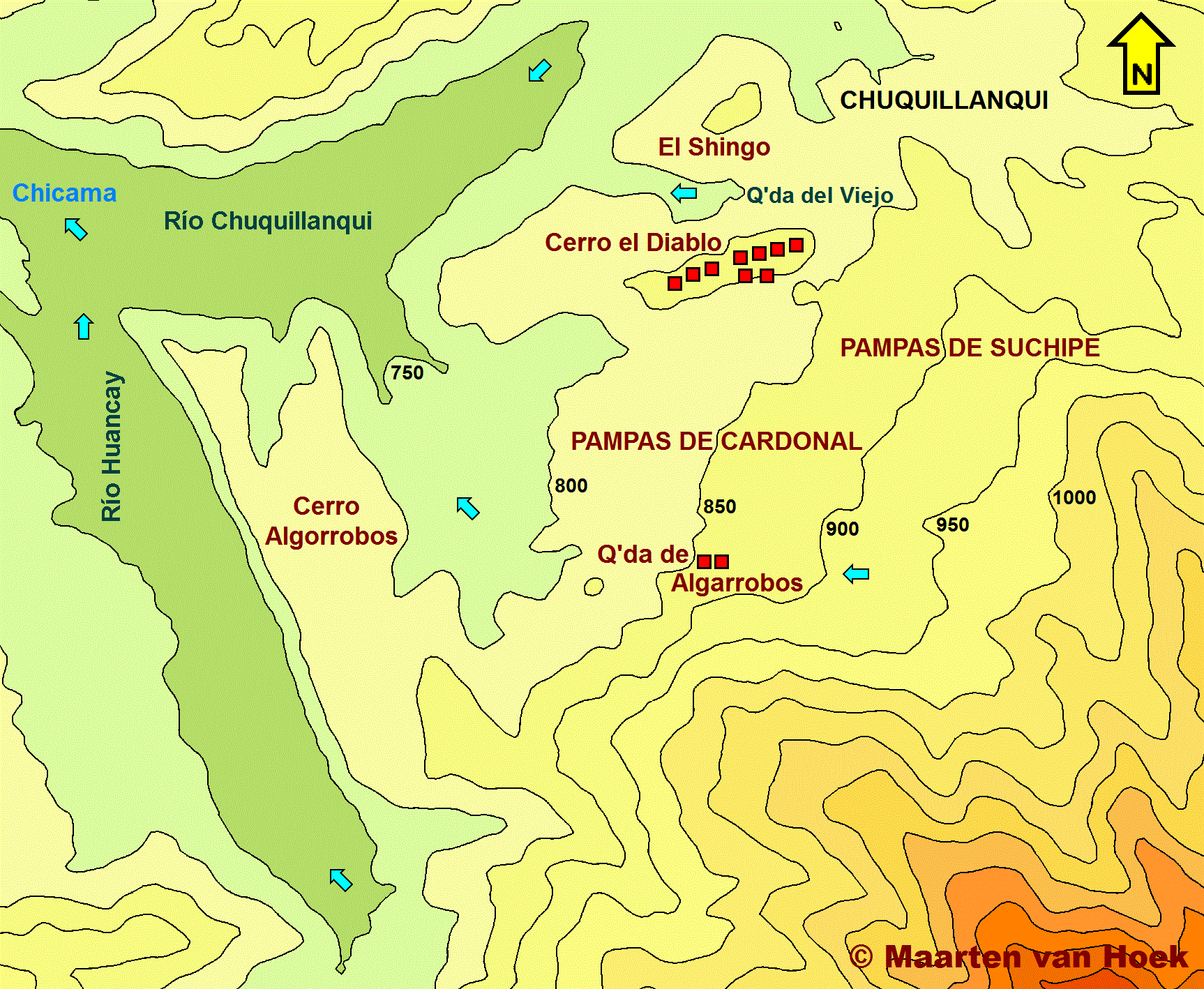
Figura 4. Mapa que muestra las ubicaciónes exactas de los dos sitios de arte rupestre en Chuquillanqui. Algunas de las posiciones de las otras características topográficas pueden ser incorrectas. Mapa © de Maarten van Hoek, basado en el mapa topográfico, Hoja 1155/16-f del Instituto Geográfico Nacional de Perú. Lima.
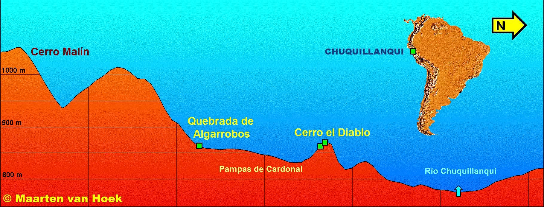
Figura 5. Sección que muestra las ubicaciones exactas de los dos sitios de arte rupestre en Chuquillanqui. Dibujo © de Maarten van Hoek, basado en Google Earth.
![]() Los Petroglifos de Chuquillanqui
Los Petroglifos de Chuquillanqui
A pesar del registro bastante completo del arte rupestre en Chuquillanqui que tengo, prefiero no ofrecer ningún tipo de inventario de todo el complejo en esta trabajo, ya estoy seguro de que no ví muchos paneles. Además, mi video en YouTube que acompaña este artículo tampoco ofrece un registro completo de todos los petroglifos. Sin embargo, se pueden hacer algunas observaciones interesantes.
En primer lugar, aparte de Zapotal (un sitio de petroglifos de menor importancia con vista al Río Huancay), Chuquillanqui probablemente es el sitio de arte rupestre ‘costera’ más oriental en la cuenca del Río Chicama. De hecho, aunque el sitio de arte rupestre de Chuquillanqui se encuentra relativamente lejos de la costa y está rodeado por los picos de los Andes Altos, su imaginería está más allá de toda duda costera de carácter y no de las tierras altas. Hay varios sitios de arte rupestre en la cuenca del Río Chicama (Figura 1) y en otros valles vecinos que confirman inequívocamente esta observación. Los petroglifos en Chuquillanqui contienen símbolos abstractos como espirales y cruces, líneas errantes, zoomorfos como monos, aves, lagartos y ‘serpientes’. Rostros antropomorfos, aunque raros, son los más importantes, ya que algunos ejemplos representados lateral y frontalmente mostran claramente las características del Estilo-MSC, mientras que varios rostros representadas frontalmente tienen una o dos orejas triangulares. Pero antes de discutir los enlaces gráficos de Chuquillanqui con otros sitios de arte rupestre en la zona de la costa, será necesario describir brevemente los dos grupos.
Cerro el Diablo
Este sitio comprende la estribación de una cresta de más o menos de 75 m de altura, en forma de Ʌ con laderas muy escarpadas al norte y al sur. La cresta extende 1100 m ENE-OSO y tiene su cima más alta (a 875 m) en su extremo este. La cresta está formado por una pirca recta de roca irregular, mucho más duro y fragmentado de las cuales muchas partes han caído por las laderas, especialmente en la ladera orientada al sur. Muchas de las superficies de la pirca superior tienen petroglifos, así como varios de los bloques caídos en la ladera sur. Por desgracia, muchas imágenes son muy difíciles de leer porque – en primer lugar – muchos de los antiguos petroglifos han meteorizados considerablemente y por otra parte están a menudo cubiertas de excrementos de aves y líquenes o están ocultos por la vegetación densa. El carácter moteado de varias superficies también provoca confusión. En muchos casos también es extremadamente difícil de separar los diferentes paneles con petroglifos, que pueden conducir a un número diferente de paneles decorados por cada recuento.
Quebrada de Algarrobos
Aproximadamente 1 km al sur de Cerro el Diablo es el sitio de Quebrada de Algarrobos, que se encuentra al pie del Cerro Carangas e inmediatamente al sur de la Quebrada de Algarrobos y las Pampas de Cardonal. Distingo dos sectores a Quebrada de Algarrobos (Figura 6). Cada sector está dominado por un afloramiento prominente rodeado de unos bloques y algunas zonas de afloramientos menores. Sin embargo, estas bloques periféricos y afloramientos menores no tienen petroglifos o solo muy pocos. Dado que nuestro tiempo en Chuquillanqui era limitado, no fue posible registrar cada panel de petroglifos. Ya que todavía no existe un inventario publicado oficialmente de los dos sitios, voy a – una vez más – usar mi propio sistema de numeración.

Figura 6. Mapa de los dos Sectores de Quebrada de Algarrobos, Chuquillanqui, Perú. Mapa © de Maarten van Hoek, basado en Google Earth.
En el Sector Este en Quebrada de Algarrobos (CHU-ALG-1) hay algunas bloques decoradas al SE del afloramiento principal, mientras que el afloramiento principal tiene la mayoría de los paneles y bloques decoradas (5 y 17 en la Figura 7). Panel CHU-ALG-1-017 es especial en dos aspectos, ya que implica un pequeño petroglifo del Estilo-MSC que ha sido ejecutado en una hendidura muy estrecha entre dos rocas. Fue imposible para mí para tomar una foto. Castillo incluido un dibujo rotado 90 grados a la izquierda (2006: Fig. 237) y como consecuencia interpreta la imagen como ‘cabeza de ave esquematizada’, mientras cuando que se observa en la posición correcta podría así representar un felino incompleto. También el dibujo de Castillo del Panel CHU-ALG-1-012 (2006: 266) muestra las imágenes de las vulvas aparentes en una posición rotada, mientras que una de las vulvas (y algunas otras ranuras) no ha sido dibujado por Castillo. Petroglifos que posiblemente representan vulvas aislados son únicos para esta zona, pero de vez en cuando ejemplos similares se han registrado en otros lugares, por ejemplo en el Panel FEL-034 en Pampa de Mosquito (Quebrada del Felino) en Jequetepeque y en Panel CCA1-015 en Cerro La Cal 1, Reque.

Figura 7. El Sector Este en Quebrada de Algarrobos, Chuquillanqui, Perú. Fotografía © por Maarten van Hoek.
El Sector Oeste (Figura 8) también tiene algunas piedras decoradas y zonas de afloramientos periféricas, pero este sector claramente está dominado por un afloramiento grande, mucho más fragmentado que emerge abruptamente desde la orilla norte de una quebrada sin nombre. En épocas lluviosos las aguas de esta quebrada erosionaron la orilla norte y la parte inferior del afloramiento, lo que podría producir algunas partes del afloramiento que caen hacia abajo (por ejemplo, los Paneles CHU-ALG-2-041 a 043). Esta erosión también hace que sea imposible hoy en día para inspeccionar los Paneles CHU-ALG-1-038 a 040 muy cerca, ya que no hay nada que estar de pie. La única manera de fotografiar estos paneles es tomar las fotos desde el lado de la colina opuesta y dar un golpe de zoom. Otro problema es que muchos paneles en este sitio se vuelven cada vez más cubiertos por la vegetación densa.

Figura 8. El Sector Oeste en Quebrada de Algarrobos, Chuquillanqui, Perú. Fotografía © por Maarten van Hoek.
Aunque muchos paneles del afloramiento tienen petroglifos, la mayor concentración de las imágenes se encuentran en la zona una vez nominado ‘El Templo’ por Rodríguez López (1976). Este ‘Templo’ es un área pequeña y ‘accesible’ dentro del afloramiento (T en la Figura 9), que está flanqueado al norte por dos enormes paneles de roca verticales, orientados al SSO (Paneles CHU-ALG-2-025 y 028 en la Figura 9; también ver la Figura 15) y – hacia el sur – paneles con una fuerte inclinación al NNE (Paneles CHU-ALG-2-030 a 034 en la Figura 9; también ver las Figuras 12 y 13). Todos los paneles están cubiertos casi en su totalidad con una gran diversidad de petroglifos, mientras que las superficies casi horizontales de la pared norte (Paneles CHU-ALG-2-050 y 051 en la Figura 9) están también cubiertas con petroglifos. Este muro norte también (ver la Figura 15) se estima que aumentará aproximadamente 3 metros de altura.
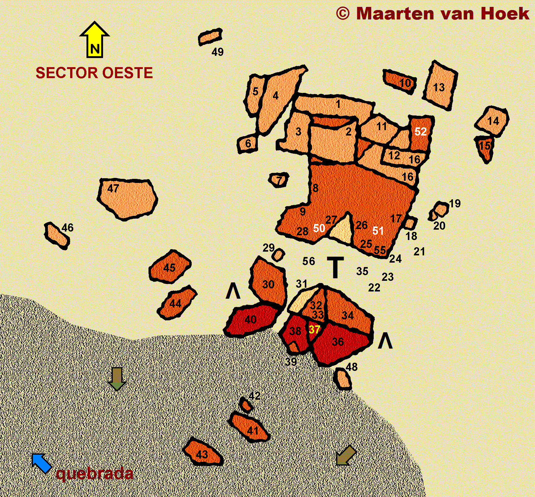
Figura 9. El Sector Oeste en Quebrada de Algarrobos, Chuquillanqui, Perú. Dibujo © de Maarten van Hoek, basado en Google Earth. Observe por favor que esto es solamente un mapa provisional muy esquemático que ninguna duda es inexacto. Las escalas para los diferentes paneles pueden ser diferentes. No todos los paneles de arte rupestre han sido indicados. Algunos paneles se encuentran más lejos.
![]() Enlaces Gráficas
Enlaces Gráficas
Una serie de imágenes en Chuquillanqui también se encuentran en otros sitios de arte rupestre costeras. Algunos petroglifos en Chuquillanqui representan zoomorfos representados lateralmente con una larga cola enroscada y pies opuestos. Lo más probable es que representan monos (no caracoles: ver Van Hoek 2013). Dos buenos ejemplos se pueden ver en Panel CHU-DIA-055 que es orientado al SE. Zoomorfos representados del mismo modo han sido registrados en los Paneles GNC-001, 006A, 016 en Cerro Negro en la cuenca del Río Chicama, a 27 km al oeste de Chuquillanqui, y en muchos otros sitios.
En Panel CHU-ALG-2-034 hay un gran símbolo de un media luna circunscrito representado con sus curvas hacia abajo (ver Figura 12). Una media luna orientada de manera similar pero totalmente picoteado aparece en el Panel GNC-001 en Cerro Negro, mientras que río más abajo hay una media luna sobre una roca muy prominente en Cruz de Botijas cerca de Ascope. También en Yonán en Jequetepeque han reportado símbolos similares.
Uno de los motivos rupestres más intrigantes en el mundo es la cruz-bordeada, también llamada la Estrella Venus (Sánchez P. 2008). Ocurre en todo el continente americano, así como en Europa, África y Oceanía. Aunque un símbolo de una cruz circunscrita ocurre en Panel CHU-DIA-119 en Cerro el Diablo, no es un ejemplo de una Estrella Venus, que también tiene una cruz interna. Por tanto, es notable que una concentración relativamente alta de la cruz-bordeada ha sido registrado en Quebrada de Algarrobos, donde no menos de seis ejemplos se han registrado. Motivos similares se han documentado en Jequepeteque, Virú, Chao, Reque, etc.
Una imagen que es único en el arte rupestre de la costa del norte de Perú es una cabeza antropomórfica representado frontalmente. Se puede faltar los rasgos faciales como la nariz, la boca o los ojos, pero siempre se caracteriza por uno o dos orejas más o menos triangular. Dos ejemplos con una oreja ocurren en Cerro el Diablo (CHU-DIA-038 y 107). También hay ejemplos en Quebrada de Algarrobos, por ejemplo en Paneles CHU-ALG-1-004, CHU-ALG-2-015 (ver Figura 18) and CHU-ALG-2-028 (ver Figura 16: flecha verde). Hay cabezas con orejas de forma similar en Cafetal y Cerro Negro en Chicama, y en Cerro Colorado cerca de Cascas. También en Alto de la Guitarra, Pampa Calata y Tomabal en Virú (Van Hoek 2007) y El Vagón en Moche hay petroglifos de cabezas con orejas triangulares. Mucho más al sur en Palamenco Núñez Jiménez ilustra una cabeza con orejas triangulares que se parece mucho al igual que el ejemplo en el panel CHU-ALG-2-028, pero es un problema que los dibujos de Núñez Jiménez no siempre son fiables (Van Hoek 2012).
Finalmente, es un hecho que al menos una (gran?) parte del repertorio de arte rupestre en Chuquillanqui data del Período Formativo, ya que algunas imágenes muestran claramente la influencia Cupisnique. Para distinguir aquellas imágenes de las imágenes estándar – de orígenes locales – he introducido un acrónimo imparcial: el Estilo-MSC, que se refiere a todas las imágenes biomórficas desde el Período Formativo que muestran ciertas características (Van Hoek 2011). En Cerro el Diablo hay una cara de perfil (en Panel CHU-DIA-119) y una cara frontal (en Panel CHU-DIA-064) que muestran propiedades del Estilo-MSC; este último tiene orejas que son más o menos similares a los orejas en el petroglifo de una cabeza de Estilo-MSC en Huancor, 710 km al SSE (Van Hoek 2011: Fig. 113). Muchas más imágenes de Estilo-MSC se encuentran en muchos valles de la costa del Perú, pero especialmente en Virú (Alto de la Guitarra), Jequetepeque (Tolón) y Reque (Cerro Mulato).
![]() Los Bordes Aserrados de las Rocas de Chuquillanqui
Los Bordes Aserrados de las Rocas de Chuquillanqui
Aparte de los motivos específicos costeros discutidos anteriormente, Chuquillanqui tiene imágenes que son muy similar al repertorio de imágenes en los otros sitios de arte rupestre en la cuenca del Río Chicama. Hay, sin embargo, una característica en Chuquillanqui que no puedo recordar haber visto en ningún otro sitio de arte rupestre al oeste de los Andes, a excepción de un posible ejemplo en Toro Muerto, Arequipa.
Caminando hacia el sur hacia Quebrada de Algarrobos nos acercamos al sitio de arte rupestre desde el este y por lo tanto primero exploramos el Sector Este. Más o menos en la parte superior del afloramiento principal hay un panel poco inclinado con petroglifos (Panel CHU-ALG-1-005). Sólo la parte relacionada de este panel se ilustra por Castillo (Figura 10). Pero porque Castillo no dibuja los bordes de la mayoría de los paneles, claramente falta una característica importante en su dibujo. El borde norte del panel presenta una fila de cinco, hendiduras regularmente especiadas (y posiblemente cinco hendiduras más hacia el oeste). Estas pequeñas hendiduras 3-dimensionales claramente son marcas antrópicas, pero definitivamente no son marcas de afilado de utillajes, que se demostrará más adelante. Las hendiduras más desarrolladas son claramente triangular y miden entre 1 y 2 cm. Son totalmente patinado y probablemente son muy antiguos. Esas hendiduras dan al borde de la roca una apariencia dentada y por lo tanto el borde se ve como una serrucho. No otros ejemplos de bordes aserrados fueron advertidos por nosotros en este sector.

Figura 10. Dibujo de una parte del Panel CHU-ALG-1-005, Quebrada de Algarrobos, Chuquillanqui, Perú, según Castillo (2006: Fig. 275).

Figura 11. Parte del Panel CHU-ALG-1-005, Quebrada de Algarrobos, Chuquillanqui, Perú. Fotografía © por Maarten van Hoek.
Sin embargo, fotografiando los paneles en ‘El Templo’ en el Sector Occidental, he notado que los vértices superiores de la formación rocosa en forma de Ʌ (Paneles CHU-ALG-2-036-034 / 037-033 / 038-032 entre los dos Ʌ’s en la Figura 9) también contó con bordes aserrados (Figuras 12, 13 and 14). Sin embargo, varias de esas hendiduras – pero no todos – resultó representar partes de petroglifos que continuaron en un panel adyacente. El panel CHU-ALG-2-034 es de mayor interés debido a dos petroglifos específicos (flechas amarillas en la Figura 12).
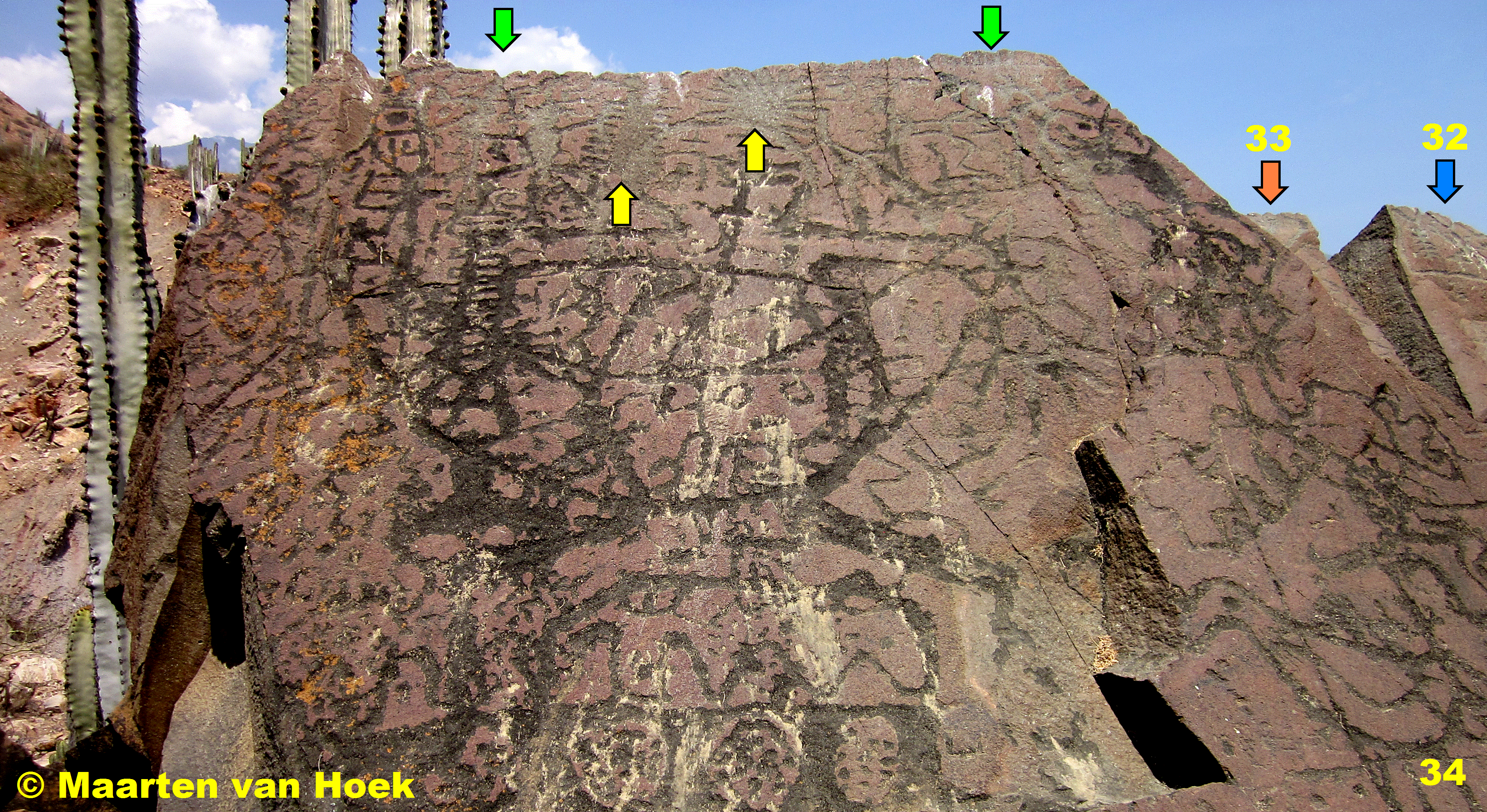
Figura 12. La parte superior del Panel CHU-ALG-2-034 en Quebrada de Algarrobos, Chuquillanqui, Perú. Fotografía © por Maarten van Hoek.

Figura 13. La parte superior del Panel CHU-ALG-2-032 en Quebrada de Algarrobos, Chuquillanqui, Perú. Fotografía © por Maarten van Hoek.

Figura 14. Las partes superiores de los Paneles CHU-ALG-2-037 y 038 en Quebrada de Algarrobos, Chuquillanqui, Perú. Fotografía © por Maarten van Hoek.
Girando hacia la pared de roca vertical que bordea ‘El Templo’ al norte (Figura 15), me di cuenta una vez más del mismo tipo de dentadura en muchos bordes. Una vez más, algunas de las hendiduras resultó ser parte de petroglifos que continuaron en un panel adyacente, pero la mayoría fueron claramente destinadas a producir bordes dentados. En Panel CHU-ALG-2-025 hay cuatro de dichos bordes dentados (Figura 15), mientras que Panel CHU-ALG-2-028 tiene dos (Figura 16). También el panel vertical CHU-ALG-2-027, parte de una cavidad triangular en lo alto del afloramiento, tiene un borde superior con hendiduras. Cerca del extremo superior del Panel CHU-ALG-2-025 también hay unas filas orientadas horizontalmente de triángulos 2-dimensional muy pequeños (Figura 15: flecha azul), que pueden expresar el mismo concepto que los bordes dentados 3-dimensional. Más abajo en el panel hay un complejo diseño de filas de triángulos positivo (totalmente picoteado) y negativos (superficie natural) que también pueden ser relacionados con su significado (Figure 15: flecha púrpura).

Figura 15. Paneles CHU-ALG-2-025 a 028 en Quebrada de Algarrobos, Chuquillanqui, Perú. Fotografía © por Maarten van Hoek. El fondo en esta foto ha sido manipulado digitalmente por mí y no representa el fondo verdadero.

Figura 16. Detalle de la parte superior del Panel CHU-ALG-2-028 en Quebrada de Algarrobos, Chuquillanqui, Perú. Fotografía © por Maarten van Hoek. El fondo en esta foto ha sido manipulado digitalmente por mí y no representa el fondo verdadero.
Algunos de esos bordes aserrados (Figura 15: flechas verdes) están tan irracionalmente colocados para considerar que fueron producidos durante las prácticas de afilado de utillajes. Sorprendentemente, ninguno de los bordes aserrados de la formación rocosa en forma de Ʌ-han sido ilustrados por Castillo (2006). Además faltan dibujos de la pared de roca más importante (Panel CHU-ALG-2-025 – 028) en su trabajo (a excepción de – posiblemente – Panel CHU-ALG-2-055; su Fig. 277).
El hecho que el borde aserrado es un elemento de arte rupestre en sí mismo y no el resultado de petroglifos continuando en todo el borde y sobre un panel adyacente, también se demuestra por el Panel CHU-ALG-2-015, que se encuentra en el extremo NE del afloramiento (ver Figura 9). Aunque Castillo incluye un dibujo (incorrecto) de dicho panel (Figura 17), él otra vez no notó la fila muy clara de hendiduras triangulares. Panel CHU-ALG-2-015 es una piedra pequeña y plana (panel incompletamente ilustrado en mi Figura 18). El borde oeste de este bloque muestra claramente una fila de 14, quizás 15 hendiduras triangulares (Figura 19), algunos de los cuales están muy bien manufacturados (Figura 20). Todas las hendiduras están claramente separados de los otros petroglifos en la superficie superior de este panel, mientras que el lado vertical no tiene petroglifos.

Figura 17. Dibujo por el arqueólogo Daniel Castillo Benites (2006: Fig. 252) del Panel CHU-ALG-2-015 en Quebrada de Algarrobos, Chuquillanqui, Perú (rotado por mí).
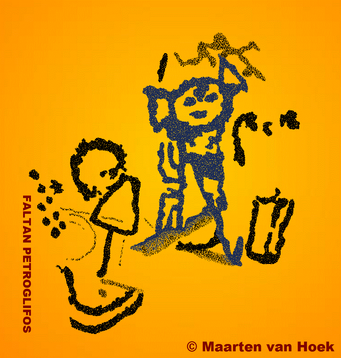
Figura 18. Panel CHU-ALG-2-015 en Quebrada de Algarrobos, Chuquillanqui, Perú. Dibujo © por Maarten van Hoek. Dado que este dibujo se basa en una foto incompleta de este panel, falta una parte muy pequeña de los petroglifos en este dibujo. Además, mi dibujo puede ser inexacto con respecto a algunos detalles.
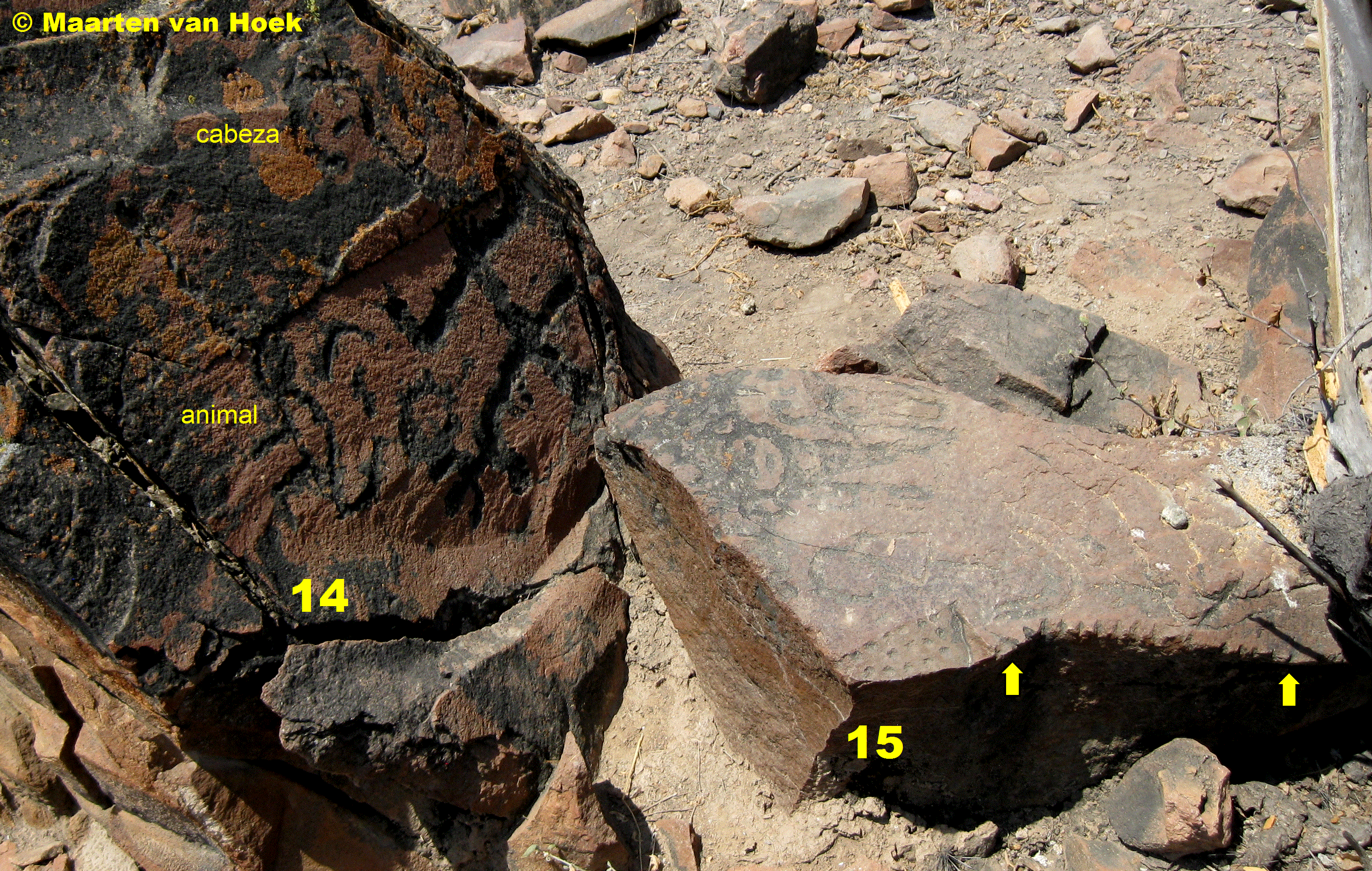
Figura 19. Paneles CHU-ALG-2-015 y 014 en Quebrada de Algarrobos, Chuquillanqui, Perú. Fotografía © por Maarten van Hoek.

Figura 20. Detalle del Panel CHU-ALG-2-015 en Quebrada de Algarrobos, Chuquillanqui, Perú. Fotografía © por Maarten van Hoek.
![]() Conclusión y Sugerencia
Conclusión y Sugerencia
Los hechos demuestran que el borde aserrado representa un elemento altamente intencional, pero rara en el arte rupestre de Quebrada de Algarrobos y, por otra parte, que su aparición es único para todo Quebrada de Algarrobos, ya que no me di cuenta de un solo borde aserrado en cualquier roca en Cerro el Diablo o en cualquier otro lugar en la cuenca del Río Chicama. La única excepción se produce en una gran roca en Toro Muerto que tiene una fila horizontal de siete u ocho hendiduras en una pequeña repisa muy cerca de la superficie del suelo (Figura 21). Pero Toro Muerto se encuentra 1170 kilometros al SE de Chuquillanqui y se encuentra en un contexto natural y cultural completamente diferente. Aunque posiblemente el significado del borde aserrado en Toro Muerto puede estar relacionado, es mucho más probable que los bordes aserrados en Quebrada de Algarrobos tienen un significado completamente diferente.

Figura 21. Bloque TM-Fa-001 en Toro Muerto, sur de Perú. Fotografía © por Maarten van Hoek.
Los bordes aserrados de Quebrada de Algarrobos representan una misteriosa forma de arte rupestre, ya que todavía es un enigma cuál ha sido el significado de esta característica, pero no hay duda de que fue significativa en los tiempos prehistóricos para ejecutar tantos bordes aserrados en solamente este sitio. La única explicación posible que yo puedo pensar hasta ahora podría ser que el manufacturero quería capturar la esencia de los enormes cactáceas que son una característica tan impresionante del paisaje al norte de Quebrada de Algarrobos. Los bordes verticales de los gigantescos cactáceas también muestran una apariencia dentada cuando se ve de perfil (ver los cactáceas en las Figuras 7, 12 y 14). Además, hay dos petroglifos totalmente picoteado en Panel CHU-ALG-2-034 que puede representar (la parte superior de) un cactus (Figura 12: flechas amarillas), mientras que en el Panel CHU-ALG-2-032 hay dos pequeños petroglifos (Figura 13: flechas amarillas) que posiblemente puede representar un cactus (flanqueando un zoomorfo), toda la escena enmarcada por un rectángulo irregular. La parte superior del rectángulo mustra triángulos formando un borde dentado. Por supuesto, este cactus-teoría simplemente es una mera especulación y yo estoy abierto a otras sugerencias.
Traducido con Google Translate (disculpen los errores)
![]()
ENGLISH VERSION
The Serrated Rock-edges of Chuquillanqui, Peru
By Maarten van Hoek – rockart@home.nl
![]() See my video about Chuquillanqui (in Spanish)
See my video about Chuquillanqui (in Spanish)
![]()
Introduction
Although little known, the rock art site of Chuquillanqui houses one of the most important rock art concentrations west of the Andes. The site actually comprises at least two different petroglyph groups: Cerro el Diablo and (1256 m due south) Quebrada de Algarrobos. The two groups are separated by the vast plain of Pampas de Cardonal (slightly sloping NW), which is filled with an impressive wood of enormous cacti locally known as ‘cardos’ or ‘gigantones’ (Neoraimondia macrostibas), which sometimes are as high as 15 m. Together with the rock art site of Alto de la Guitarra (in Virú), Chuquillanqui is one of the most impressive sites that I have visited in South America. To me it is an almost magical site.
The complex is located in the Upper Drainage of the Río Chicama (Figure 1), about 77 km inland (as the crow flies) at an average altitude of about 850 m. To the north the area is bordered by the Río Chuquillanqui and to the west by the Río Huancay. From certain spots at both sites the confluence of those two rivers can be seen. They join near the hamlet of El Tambo and form the Río Chicama which in turn joins the Pacific Ocean, 89 km further SW. The complex is set in a most spectacular landscape framed by impressive mountains. Directly to the south is the steep wall of a chain of mountains formed by (from west to east) Cerro Malín, Cerro Colorado and Cerro Carangas (Figure 2). To the SW, across the Río Huancay is the even higher mountain range of Cerro Luanga. To the east is Cerro Negro and to the north the peaks of Cerro Chin Chin dominate the skyline. To the west the peak of Cerro la Carcel and its outliers south of the valley of the Río Chicama can be seen.
Click the word Figure (red and underlined) in each caption to see the illustration (click to enlarge). Use the back arrow to return to the text
Figure 1. Location of Chuquillanqui and other rock art sites in the drainage of the Río Chicama. Map © by Maarten van Hoek, based on Google Earth.
Figure 2. Location of the petroglyph site of Quebrada de Algarrobos. Photograph © by Maarten van Hoek.
![]() Past Research
Past Research
It seems that the German explorer Hans Dieter Disselhoff was the first to mention the rock art at Chuquillanqui (1955: 60). After a silence of more than 20 years archaeologist Luis Rodríguez López published a booklet about the rock art at Chuquillanqui (1976). Although very useful regarding background information, the booklet offers very little in terms of description of the petroglyphs. Moreover, only eight photos of rock art panels and six drawings were included. Rainer Hostnig included Chuquillanqui into his Inventario Nacional (2003: 202 and 215) together with two illustrations taken from the booklet by Rodríguez López (1976) and two photos supplied by Daniel Castillo. In 1991 Rodríguez López published a further article about Chuquillanqui and in 2006 Rodríguez López, together with archaeologist Daniel Castillo Benites, presented a paper at the II Simposio Nacional de Arte Rupestre (Trujillo), of which the very short text with 19 unnumbered photos and one map once was available via the internet. It seems that up to 2005 no attempt was made to separate the images at Cerro el Diablo and Quebrada de Algarrobos in any publication.
However, the most extensive survey about Chuquillanqui was published in 2006 by Daniel Castillo Benites (2006: 77-93). Castillo included many B&W drawings of many petroglyphs (2006: Figs 174-283). Although he clearly separated the descriptions and the illustrations of the two sites (Cerro el Diablo and Quebrada de Algarrobos), his drawings – though very useful – are not always reliable. There are several drawings in which petroglyphs are missing or incorrectly rendered, like his Fig. 213 (Figure 3). It is also certain that some of his drawings have (unintentionally) been mirrored horizontally (like his Fig. 271), rotated (like his Figs 237 and 266) or that the petroglyphs of one panel or boulder have been included as two different and separate illustrations, incorrectly giving the impression that it concerns two different panels (like his drawings Figs 23 and 27; 160 and 161). Finally, Castillo does not always group together drawings that are on neighbouring panels, like his Figs 246, 263, 262, 255 and 248; see Van Hoek 2016a).
Figure 3. Petroglyphs on a rock panel at Cerro el Diablo. Drawing © by Maarten van Hoek. Blue inset: the same panel as drawn by archaeologist Daniel Castillo Benites (2006: Fig. 213).
Finally, although Castillo includes a very large number of drawings of the petroglyph panels that he recorded at Chuquillanqui, it is certain that his survey only represents an impression of what is available. Castillo includes 110 illustrations of rock art ‘panels’ in his section about Chuquillanqui (2006: 77-93). However, it is a problem that especially at Chuquillanqui is extremely difficult to distinguish between panels. The rocks at both groups – involving outcrops and boulders – are much fragmented and, what is more, petroglyphs often continue on different panels. The use of the term ‘panel’, also in my survey, is therefore rather ambiguous. Rodríguez López (1976: 26) mentions the existence of 298 ‘petroglifos’ at the two sites of Chuquillanqui. However, several Peruvian archaeologists use the word ‘petroglifo’ to indicate a rock panel with one or more images, whereas in my view a petroglyph is just one image (see Van Hoek 2016b). At the moment I have a photographic record of 196 ‘panels’ (123 at Cerro el Diablo – 73 at Quebrada de Algarrobos) and when including the illustrations of the rock art ‘panels’ published by other researchers, the Grand Total of illustrations that I have available is 269 ‘panels’. If indeed the Grand Total mentioned by Rodríguez López (1976: 26) is 298 ‘panels’, my personal record of 269 ‘panels’ offers a solid base to discuss the rock art at Chuquillanqui.
Maps of Chuquillanqui
It proved to be rather confusing to use and interpret the maps (and the corresponding descriptions) of Chuquillanqui in published works. Several authors mention names of pampas, quebradas, hills and mountains that cannot be found on any map. Possibly, two names may even indicate the same topographical feature. For that reason Chuquillanqui has been included in his Inventario Nacional by Rainer Hostnig as Cerro Banderas (2003: 199), Cerro Del Diablo (2003: 200), Chuquillanqui (o Cerro del Diablo) (2003: 202) and Quebrada Algarrobos (2003: 208).
The map published by Rodríguez López (1976) is very small and only includes the names of the quebradas, while the two groups are not aligned in the correct N-S line, but in a NW-SE line. Moreover, on his map Rodríguez López does not mention the Quebrada de Algarrobos, but instead Quebrada de Cardonal, while he locates the group of Quebrada de Algarrobos north of Quebrada de Algarrobos, instead of directly south. Rodríguez López also introduced the name of Cerro Banderas, but does not indicate that site on his map. The map published by Rodríguez López and Castillo Benites (2006) is more disturbing, especially regarding the contours. On their map are the names of two hills (Cerro Chichero and Cerro Sanchez Cerro) of which Cerro Sanchez Cerro is another name for Cerro Banderas (Rodríguez López 1976: 25). Most likely Cerro Banderas is also another name for Cerro el Diablo. What is more confusing is that, according to their north arrow, they locate Cerro el Diablo SE of (Quebrada?) Algarrobos and, moreover, incorrectly at the foot of Cerro Carangas.
Finally, Castillo (2006: 78) is correct stating that Cerro el Diablo is 1.5 km due south of the hamlet of ‘9 de Octubre’, but unfortunately Castillo does not include a map of the area and therefore the rock art site of El Shingo, which is located – according to Castillo (2006: 79) – only 100 m from Cerro el Diablo (a ridge that measures no less than 1100 m in a ENE-WSW direction) cannot be located by me with certainty. Because of this confusion I made a map and a section (Figures 4 and 5) indicating the correct locations of the two rock art groups, plus the names of several topographical features (some of which – like El Shingo and Cerro Algarrobos – may be incorrectly indicated on my map, Figure 4).
Figure 4. Map showing the exact locations of the two rock art sites at Chuquillanqui. Some of the positions of the other topographical features may be incorrect. Map © by Maarten van Hoek, based on the topographical map, Sheet 1155 / 16-f of the Instituto Geografico Nacional de Perú. Lima.
Figure 5. Section showing the exact locations of the two rock art sites at Chuquillanqui. Drawing © by Maarten van Hoek, based on Google Earth.
![]() The Petroglyphs of Chuquillanqui
The Petroglyphs of Chuquillanqui
Despite the rather complete record of the rock art at Chuquillanqui that I have, I prefer not to offer any kind of inventory of the whole complex in this survey, as I am sure that I missed a lot of panels. Also my YouTube video that accompanies this paper does not offer a full record of all petroglyphs. Yet some interesting remarks can be made.
First of all, apart from Zapotal (a minor petroglyph site directly overlooking the Río Huancay), Chuquillanqui probably is the easternmost ‘coastal’ rock art site in the Chicama drainage. Indeed, although the rock art site of Chuquillanqui is found relatively far inland and is surrounded by peaks of the High Andes, its imagery is beyond any doubt coastal and not highland of character. There are several rock art sites in the Chicama drainage (see Figure 1) and in other neighbouring river valleys that unambiguously confirm this observation. The petroglyphs at Chuquillanqui comprise abstract symbols like spirals and crosses, wandering lines, zoomorphs like monkeys, birds, lizards and ‘snakes’. Anthropomorphic faces, although rare, are most important, as some laterally and frontally depicted examples clearly show MSC-Style characteristics, while several frontally depicted faces have one or two triangular ears. But before discussing the graphical links of Chuquillanqui with other coastal rock art sites, it will be necessary to briefly describe the two groups.
Cerro el Diablo
This site comprises the crest of a roughly 75 m high, Ʌ-shaped ridge with very steep slopes to the north and south. The ridge runs 1100 m ENE-WSW and has its highest summit (at 875 m) at its east end. The crest is formed by an irregular straight band of much fragmented harder outcrop rock of which many parts have fallen down the slopes, especially on the south facing slope. Many of the surfaces of the top ridge have petroglyphs, as well as several of the fallen blocks on the south slope. Unfortunately, many images are very hard to read because – first of all – many of the ancient petroglyphs have weathered considerably and moreover are often covered in bird droppings and lichens or are concealed by dense vegetation. The mottled nature of several surfaces also causes confusion. In many cases it is also extremely difficult to separate the different panels with petroglyphs, which may lead to a different number of decorated panels on each count.
Quebrada de Algarrobos
About 1 km due south of Cerro el Diablo is the site of Quebrada de Algarrobos, which is located at the very foot of Cerro Carangas and immediately south of the Quebrada de Algarrobos and the Pampas de Cardonal. I distinguish two Sectors at Quebrada de Algarrobos (Figure 6). Each Sector is dominated by a prominent outcrop surrounded by a few boulders and some minor outcrop areas. However, these outlying boulders and minor outcrops do not have petroglyphs or just very few. Since our time at Chuquillanqui was limited, it was not possible to record every petroglyph panel. As there still does not exist an officially published inventory of the two sites, I will – again – use my own numbering system.
Figure 6. Map of the two Sectors at Quebrada de Algarrobos, Chuquillanqui, Peru. Map © by Maarten van Hoek, based on Google Earth.
The East Sector at Quebrada de Algarrobos (CHU-ALG-1) has a few decorated boulders SE of the main outcrop, whereas the main outcrop (5, 12 and 17 in Figure 7) has the majority of the decorated panels and boulders. Panel CHU-ALG-1-017 is special in two respects as it involves a small petroglyph of the MSC-Style that has been executed in a very narrow cleft between two rocks. It proved to be impossible for me to take a photo. Castillo included a drawing that has been rotated 90 degrees to the left (2006: Fig. 237) and as a consequence he interprets the image as ‘cabeza de ave esquematizada’ (a stylised bird’s head), while viewed in the correct position it could well depict an unfinished feline. Also the drawing by Castillo of Panel CHU-ALG-1-012 (2006: 266) shows the images of the apparent vulvas in a rotated position, while one of the vulvas (and some other grooves) has not been drawn by Castillo. Petroglyphs possibly depicting isolated vulvas are unique for this zone, but similar examples have occasionally been recorded elsewhere, for instance on Panel FEL-034 at Pampa de Mosquito (Quebrada del Felino) in Jequetepeque and on Panel CCA1-015 at Cerro La Cal 1, Reque.
Figure 7. The East Sector at Quebrada de Algarrobos, Chuquillanqui, Peru. Photograph © by Maarten van Hoek.
The West Sector (Figure 8) also has a few outlying decorated boulders and outcrop areas, but this sector is clearly dominated by a large, much fragmented outcrop that emerges steeply from the north bank of an unnamed quebrada. In wet times the waters of this quebrada eroded the north bank and the lower part of the outcrop, possibly causing some parts of the outcrop to fall down (for instance Panels CHU-ALG-2-041 to 043). This erosion also makes it impossible today to inspect the Panels CHU-ALG-1-038 to 040 from close by, as there is nothing to stand on. The only way to photograph those panels is to take the photos from the opposite hill side and zoom in. Another problem is that many panels at this site become increasingly overgrown with dense vegetation.
Figure 8. The West Sector at Quebrada de Algarrobos, Chuquillanqui, Peru. Photograph © by Maarten van Hoek.
Although many panels of the outcrop feature petroglyphs, the major concentration of images is found in the area once nominated ‘The Temple’ (el Templo) by Rodríguez López (1976). This ‘Temple’ is a small, ‘accessible’ area within the outcrop (T in Figure 9) that is flanked by two enormous vertical, SSW facing rock panels to the north (Panels CHU-ALG-2-025 and 028 in Figure 9; see also Figure 15) and steeply sloping and NNE facing panels to the south (Panels CHU-ALG-2-030 to 034 in Figure 9; see also Figures 12 and 13). All those panels are almost entirely covered with a large diversity of petroglyphs, while the nearly horizontal upper surfaces of the northern wall (Panels CHU-ALG-2-050 and 051 in Figure 9) are also covered with petroglyphs. This northern wall (see Figure 15) is estimated to rise approximately 3 meters high.
Figure 9. The West Sector at Quebrada de Algarrobos, Chuquillanqui, Peru. Drawing © by Maarten van Hoek, based on Google Earth. Please notice that this is only a provisional sketch-map that no doubt is inaccurate. The scales for the different panels may differ. Not all rock art panels have been indicated. Some panels are found further away.
![]() Graphical Links
Graphical Links
A number of images at Chuquillanqui are also found in other coastal rock art sites. Some petroglyphs at Chuquillanqui represent fully laterally depicted zoomorphs with a long curled tail and opposing feet. They most likely represent monkeys (not snails: see Van Hoek 2013). Two fine examples can be seen on SE facing Panel CHU-DIA-055. Similarly depicted zoomorphs have been recorded on Panels CNG-001, 006A, 016 at Cerro Negro in the Chicama drainage, 27 km west of Chuquillanqui, and at many other sites.
On Panel CHU-ALG-2-034 is a large outlined crescent symbol with its curves pointing downwards (see Figure 12). A similarly orientated but fully pecked crescent appears on Panel CNG-001 at Cerro Negro, while further downstream an outlined crescent appears on a prominent menhir-like boulder at Cruz de Botijas near Ascope. Also at Yonán in Jequetepeque similar crescents have been reported.
One of the most intriguing rock art motifs in the world is the outlined cross, also called the Venus Star (Sánchez P. 2008). It appears throughout the Americas, as well as in Europe, Africa and Oceania. Although an outlined cross symbol occurs on Panel CHU-DIA-119 at Cerro el Diablo, it is not an example of a Venus cross, which also has an internal cross. It is therefore remarkable that a relatively high concentration of outlined crosses has been recorded at Quebrada de Algarrobos, where no less than six examples have been recorded. Similar motifs have been recorded in Jequepeteque, Virú, Chao, Reque etc.
An image that is unique to the coastal rock art of northern Peru is a frontally depicted, anthropomorphic head. It may lack facial features like nose, mouth or eyes, but it is always characterised by one or two roughly triangular ears. Two examples with one ear each occur at Cerro el Diablo (CHU-DIA-038 and 107). Also at Quebrada de Algarrobos examples occur, for instance on Panels CHU-ALG-1-004, CHU-ALG-2-015 (see Figure 18) and CHU-ALG-2-028 (see Figure 16: green arrow). Heads with similarly shaped ears occur at Cafetal and Cerro Negro in Chicama, and at Cerro Colorado near Cascas. Also at Alto de la Guitarra, Pampa Calata and Tomabal in Virú (Van Hoek 2007) and El Vagón in Moche heads with triangular ears occur. Much further south at Palamenco Núñez Jiménez illustrates a head with triangular ears that looks much the same as the example on Panel CHU-ALG-2-028, but it is a problem that the drawings by Núñez Jiménez are not always reliable (Van Hoek 2012).
Finally, it is a fact that at least a (large?) part of the rock art repertoire at Chuquillanqui dates from the Formative Period, as some images clearly show Cupisnique influence. To distinguish those images from the standard – local – imagery I have introduced an unbiased acronym: the MSC-Style, which refers to all biomorphic images from the Formative Period that show certain characteristics (Van Hoek 2011). At Cerro el Diablo are a profile face (on Panel CHU-DIA-119) and a frontal face (on Panel CHU-DIA-064) that show MSC-Style properties; the latter has ears that are more or less similar to the ears in the MSC-Style head petroglyph at Huancor, 710 km to the SSE (Van Hoek 2011: Fig. 113). Many more MSC-Style images are found in many valleys of coastal Peru, but especially in Virú (Alto de la Guitarra), Jequetepeque (Tolón) and Reque (Cerro Mulato).
![]() The Serrated Rock-edges of Chuquillanqui
The Serrated Rock-edges of Chuquillanqui
Apart from the specific coastal motifs discussed above, Chuquillanqui has imagery that is very similar to the array of images at the other rock art sites in the Chicama drainage. There is, however, one feature at Chuquillanqui that I cannot remember to have seen anywhere else in a rock art site west of the Andes, except for one possible example at Toro Muerto, Arequipa.
Walking south towards Quebrada de Algarrobos we approached the rock art site from the east and thus first explored the East Sector. More or less at the top of the main outcrop is a slightly inclined surface with petroglyphs (Panel CHU-ALG-1-005). Only the relevant part of this panel is illustrated by Castillo (Figure 10). But because Castillo does not draw the edges of most panels, an important feature is missing in his drawing. The north edge of the panel features a row of five, regularly spaced indentations (Figure 11) and possibly five more further west. These small, 3-dimensional notches are clearly anthropic marks, but are definitely not tool-sharpening marks, which will be demonstrated further on. The best developed notches are clearly triangular and measure between 1 and 2 cm. They are fully patinated and probably are very old. Those notches give the rock edge a serrated appearance and thus the edge looks like a saw. No other examples of serrated edges were noticed by us in this sector.
Figure 10. Drawing of a part of Panel CHU-ALG-1-005, Quebrada de Algarrobos, Chuquillanqui, Peru, after Castillo (2006: Fig. 275).
Figure 11. Part of Panel CHU-ALG-1-005, Quebrada de Algarrobos, Chuquillanqui, Peru. Photograph © by Maarten van Hoek.
However, photographing the rock panels in the ‘Temple’ at the West Sector, I noticed that the upper apexes of the Ʌ-shaped rock formation (Panels CHU-ALG-2-036-034 / 037-033 / 038-032 between the two Ʌ’s in Figure 9) also featured serrated edges (Figures 12, 13 and 14). Yet, several of those notches – but not all – proved to represent parts of petroglyphs that continue on an adjacent panel. Panel CHU-ALG-2-034 is of further interest because of two specific petroglyphs (yellow arrows in Figure 12).
Figure 12. The upper part of Panel CHU-ALG-2-034 at Quebrada de Algarrobos, Chuquillanqui, Peru. Photograph © by Maarten van Hoek.
Figure 13. The upper part of Panel CHU-ALG-2-032 at Quebrada de Algarrobos, Chuquillanqui, Peru. Photograph © by Maarten van Hoek.
Figure 14. The upper parts of Panels CHU-ALG-2-037 and 038 at Quebrada de Algarrobos, Chuquillanqui, Peru. Photograph © by Maarten van Hoek.
Turning towards the vertical rock wall bordering ‘The Temple’ to the north (Figure 15), I once more noticed the same type of serration at many edges. Again, some of the indentations proved to be part of petroglyphs that continued on an adjacent panel, but most were clearly intended to produce serrated edges. On Panel CHU-ALG-2-025 are four of such serrated edges (Figure 15), while Panel CHU-ALG-2-028 has two (Figure 16). Also vertical Panel CHU-ALG-2-027, part of a triangular cavity high upon the outcrop, has an upper edge with indentations. Near the top end of Panel CHU-ALG-2-025 are also a few horizontally orientated rows of very small, 2-dimensional triangles (Figure 15: blue arrow) that may express the same concept as the 3-dimensional serrated edges. Lower down the panel is a complex pattern of rows of positive (fully pecked) and negative (natural surface) triangles that may be meaning-related as well (Figure 15: purple arrow).
Figure 15. Panels CHU-ALG-2-0325 to 028 at Quebrada de Algarrobos, Chuquillanqui, Peru. Photograph © by Maarten van Hoek. The background in this photo has been digitally manipulated by me and does not represent the true backdrop.
Figure 16. Detail of the upper part of Panel CHU-ALG-2-028 at Quebrada de Algarrobos, Chuquillanqui, Peru. Photograph © by Maarten van Hoek. The background in this photo has been digitally manipulated by me and does not represent the true backdrop.
A few of those serrated edges (Figure 15: green arrows) are so irrationally placed to even consider that they were produced during tool-sharpening practices. Surprisingly, none of the serrated edges of the Ʌ-shaped rock formation have been illustrated by Castillo (2006). Moreover, drawings of the most important rock wall (Panel CHU-ALG-2-025 – 028) are missing in his survey (except for – possibly – Panel CHU-ALG-2-055; his Fig. 277).
The fact that the serrated edge is a rock art element in itself and not the result of continuing petroglyphs across the edge and onto an adjacent panel, is also demonstrated by Panel CHU-ALG-2-015, which is located at the extreme NE edge of the outcrop (see Figure 9). Although Castillo includes an (incorrect) drawing of that panel (Figure 17), he again failed to notice the very clear row of triangular notches. Panel CHU-ALG-2-015 involves a small, flat boulder (panel incompletely illustrated in Figure 18). The west edge of the stone clearly shows a row of 14, perhaps 15 triangular notches (Figure 19), some of which are very well manufactured (Figure 20). All the notches are clearly separated from the other petroglyphs on the upper surface of this panel, while the vertical side has no petroglyphs.
Figure 17. Drawing by archaeologist Daniel Castillo Benites (2006: Fig. 252) of Panel CHU-ALG-2-015 at Quebrada de Algarrobos, Chuquillanqui, Peru (rotated by me).
Figure 18. Panel CHU-ALG-2-015 at Quebrada de Algarrobos, Chuquillanqui, Peru. Drawing © by Maarten van Hoek. As this drawing is based on an incomplete photo of this panel, a very small part of the petroglyphs is lacking in this drawing. Moreover, my drawing may be inaccurate regarding some details.
Figure 19. Panels CHU-ALG-2-015 and 014 at Quebrada de Algarrobos, Chuquillanqui, Peru. Photograph © by Maarten van Hoek.
Figure 20. Detail of Panel CHU-ALG-2-015 at Quebrada de Algarrobos, Chuquillanqui, Peru. Photograph © by Maarten van Hoek.
![]() Conclusion and Suggestion
Conclusion and Suggestion
The facts prove that the serrated edge represents a highly intentional but rare element in the rock art of Quebrada de Algarrobos and, moreover, that its appearance is unique for especially Quebrada de Algarrobos, as I did not notice a single serrated edge at any rock at Cerro el Diablo or anywhere-else in Chicama. The only exception occurs on a large boulder at Toro Muerto that has a horizontal row of seven or eight indentations on a small ledge very near the ground surface (Figure 21). But Toro Muerto is located 1170 km SE of Chuquillanqui and is set in a completely different natural and cultural context. Although possibly the meaning of the Toro Muerto serrated edge may be related, it is much more likely that the serrated edges at Quebrada de Algarrobos have a completely different meaning.
Figure 21. Boulder TM-Fa-001 at Toro Muerto, southern Peru. Photograph © by Maarten van Hoek.
The serrated edges of Quebrada de Algarrobos represent a mysterious form of rock art, as it still is a complete enigma what the meaning of this feature has been, but no doubt it was significant in prehistoric times to execute so many serrated edges at only this site. The only possible explanation that I can so far think of could be that the manufacturer wanted to capture the essence of the enormous cacti that are such an impressive feature of the landscape north of Quebrada de Algarrobos. The vertical edges of those gigantic cacti also show a serrated appearance when viewed in profile (see the cacti in Figures 7, 12 and 14). Moreover, there are two fully pecked petroglyphs on Panel CHU-ALG-2-034 that may well represent (the tops of) cacti (see Figure 12; yellow arrows), while on Panel CHU-ALG-2-032 are two small petroglyphs (flanking a zoomorph), the whole scene framed by an irregular box, that may possibly represent cacti (see Figure 13; arrows). The top of the box shows triangles the top of which form a serrated edge. Of course this cactus-theory is just mere speculation and I am open to other suggestions.
![]() Referencias / References
Referencias / References
Castillo Benites, D. S. 2006. Arte Rupestre en La Cuenca del Chicama. Primera edición, Ediciones Sian, Trujillo.
Disselhoff, H. D. 1955. Neue Fundplätze peruanischer Felsbilder. En: Baessler Archiv. Neue Folge. Vol. 3; pp. 55 – 73. Berlin.
Hostnig, R. 2003. Arte rupestre del Perú. Inventario Nacional. CONCYTEC, Lima, Perú.
Rodríguez López, L. F. 1976. Los petroglifos de Chuquillanqui. Departamento de Ciencias de la Educación, Universidad Nacional de Trujillo, Trujillo, Perú.
Rodríguez López, L. F. 1991. Petroglifos de Chuquillanqui. En: Revista del Museo de Arqueología. Vol. 2; pp. 65 – 84. Universidad Nacional de Trujillo. Trujillo. Perú.
Rodríguez López, L. F. y D. Castillo Benites. 2006. Los petroglifos de Chuquillanqui. Ponencia: II Simposio de Arte Rupestre. Trujillo.
Sánchez P., Domingo. 2008. El símbolo de Venus en el arte rupestre de Perú, Chile y norte de Argentina. En: Rupestreweb.
Van Hoek, M. 2007. Petroglifos Chavinoides cerca de Tomabal, Valle de Virú, Perú. En: Boletín de SIARB. Vol. 21; pp. 76 – 88. La Paz, Bolivia. PDF.
Van Hoek, M. 2011. The Chavín Controversy – Rock Art from the Andean Formative Period. Oisterwijk, The Netherlands. Academia.
Van Hoek, M. 2012. Cerro Mulato: el caso de Piedra 274. En: Rupestreweb.
Van Hoek, M. 2013. Santa Rita, a Petroglyph Site in the Chao Valley, Northern Peru. En: Rupestreweb.
Van Hoek, M. 2016a. Rock Art of the Nepeña Valley, Peru. Part 2: The South Bank – Discussion. Oisterwijk, Holland. PDF.
Van Hoek, M. 2016b. Sobre Dibujos de Arte Rupestre (Andino). Una Petición Para Sólo Publicar Dibujos Que Son Científicamente Sólidos. En: TRACCE – On-line Rock Art Bulletin.
TRACCE (ISSN 2281-972X) Online Rock Rock Art Bulletin è edito dalla Cooperativa Archeologica Le Orme dell’Uomo, anche indicata come Footsteps of Man e che ha sede in Valcamonica (piazza Donatori di Sangue 1, Cerveno, BS – I).
TRACCE (ISSN 2281-972X), an Italian word for “Tracks”, since 1996 is the first online Rock Art Bulletin. It is maintained by Footsteps of Man archaeological society (Valcamonica – I).


Serrated edges are present at one of the two large grey-black rocks at Checta. Seen from the front it looks like the two sides of a house roof with serrations along the ridge.
There are also serrated edges along a ridge of a massive boulder at Cochineros, though they are difficult to access and only visible under certain lighting conditions.