![]()
The Sama Valley in southern Peru has only a few rock art sites. This article describes one of those sites, which is located at Coropuro on the south bank of the river. It has a interesting collection of petroglyphs, some of which might be linked to a previously unnoticed geoglyph nearby.
By Maarten van Hoek
*
Petroglyphs and a New Geoglyph in the Sama Valley
Tacna, Peru
![]()
Maarten van Hoek
Spanish version below – Versión Español abajo
Click on any illustration to see an enlargement
Introduction
It is a fact that – especially in the coastal deserts of southern Peru and northern Chile (an area also known as the Desert Andes) – petroglyph sites and geoglyph sites are sometimes found relatively close together in the same area. A fine example is the geoglyph at Cíceras in the Majes drainage in southern Peru, which is found only 940 m (as the crow flies) east of the petroglyph site of Cíceras (Van Hoek 2021a). Moreover, geoglyphs and petroglyphs occasionally display the same type of imagery, like the camelids at Cíceras, which mirror several petroglyphs of camelids at nearby Cíceras, and the geoglyphs of Huacán (also in the Majes drainage), which are very similar to petroglyphs at Toro Muerto (Van Hoek 2021b). Attempting to locate a petroglyph site near Coropuro in the Sama Valley of southern Peru using Google Earth, I also noticed a large feature close to the petroglyph site, which possibly represents a previously unknown geoglyph. This study tentatively proposes that the purported geoglyph at Coropuro has possible parallels in the imagery of the nearby rock art site of Coropuro (Figure 1).

Figure 1. The location of the purported geoglyph at Coropuro (oval frame; enlarged in the inset to the right) and the approximate location of the petroglyph site of Coropuro (rectangular frame). Illustrations © by Maarten van Hoek, based on Google Earth.
*
The Petroglyphs of Coropuro
About 85 km inland from the village of Boca del Río on the Pacific coast of southern Peru (and more than 100 km when following the course of the Río Sama) archaeologist Richard Ochoa Peña – SACRUN SAC (Arequipa) recorded the petroglyph site of Coropuro on the lower slopes of Cerro Resbaladero in the Sama Valley. Further south of Cerro Resbaladero the summit of Cerro Caquilluco forms the highest point in the immediate area at 3890 m. To the west of the site there is the deep gully of Quebrada Cobaya. The slopes of Cerro Resbaladero are completely bereft of vegetation (Figure 2), but is strewn with debris, smaller fragments of rocks and some larger boulders of red volcanic stone, which were the target of the prehistoric people who created their images on the rock surfaces.
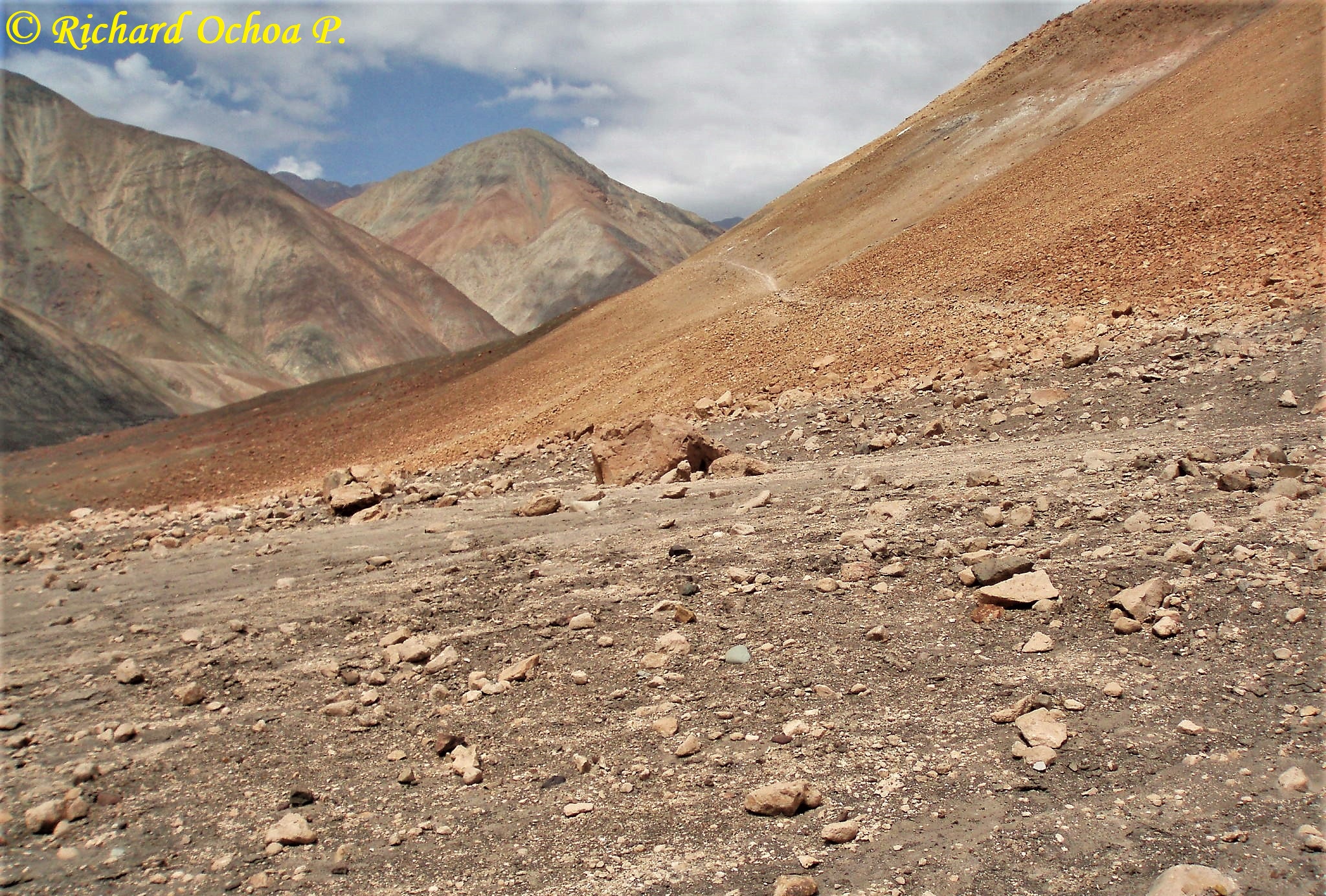
Figure 2. View from the petroglyph site of Coropuro, looking east. Notice the ancient path. The petroglyph boulders are located in the grey-sand area in the foreground. Photograph © Richard Ochoa Peña – SACRUN SAC (Arequipa).
This remote site is not mentioned in the inventory compiled by Rainer Hostnig (2003). But in a publication about Miculla (an extensive petroglyph site in the extreme south of Peru) Gordillo Begazo mentions that there are hear-say records of petroglyph sites in the Sama Valley along a track that connects Coruco (also known as Quebrada Gil; at 850 m asl) with Chucatamani at 2400 m asl (1992: 57, 60; exactly the same text and map appear in Gordillo Begazo 1996: 99, 102), but no further details – like a site name – were available. Finally, the name of the petroglyph site of Coropuro is only mentioned by Gordillo Begazo (2004: 344).
Coropuro is a large boulder field located at an average altitude of 1845 m asl, while the valley floor of the Río Sama to the north (about 215 m downslope) is at 1790 m asl. It is unknown how many boulders have been recorded, but based on the photographs published by Richard Ochoa, I tentatively estimate that there are around twenty to thirty boulders with petroglyphs.
The imagery at Coropuro definitely belongs to the rock art tradition of southern Peru (its northernmost limit being the Locumba drainage) and northern Chile (its southernmost limit being the Camarones drainage). For example, the petroglyphs of (fully pecked) camelids on Boulder COR-008 (Figure 3A) show the same pose and the typical downward bent tail as several camelid petroglyphs at Miculla, 45 km to the SSE (Figure 3B).

Figure 3. A: Petroglyphs of three camelids on Boulder COR-008 at Coropuro, southern Peru. B: Petroglyphs at Miculla, southern Peru. A: Drawing © by Maarten van Hoek, based on a photograph by Richard Ochoa Peña – SACRUN SAC (Arequipa). B: Photograph © by Maarten van Hoek.
But especially the petroglyph of the purported profile “flute-player” on Boulder COR-004 (Figure 4; see also Figure 10A-3) is almost identical to several images of “flute-players” in the area, for instance on Boulders MIN-033, MIN-046 and MIN-055 at Miculla-North. The Coropuro “flute-player” has the typical flexed legs and the floating head that is clearly separated from the body. The large appendage from the genital area does not represent male sex, although a few “flute-player” petroglyphs at Miculla do show male sex plus a second appendage. This (second) appendage of the “flute-player” is part of a garment that is typical for this rock art tradition. Also the headgear (?) of the anthropomorph on Boulder COR-008 may be mirrored on Boulder MIM-014 at Miculla-Medio.

Figure 4. A: Location of Boulder COR-004 (17°28’55.21″S and 70°15’20.07″O in Google Earth 2011) at Coropuro, southern Peru, looking south towards Cerro Resbaladero. B: Close-up of the panel. Photographs © by Richard Ochoa Peña – SACRUN SAC (Arequipa).
Of course, like many rock art sites, Coropuro also has its specialties. Special – and probably unique – is the large central bowl-shaped depression on Boulder COR-001 that is surrounded by four narrow ringmarks and a broad and deeply recessed fifth ring (Figure 5). On the same panel is a deeply carved petroglyph that seems to represent a human head. Because of the T-shaped groove emerging from the top of the head it may well be a “trophy” head (larger arrow and inset in Figure 5). Finally, Boulder COR-001 has a row of four small petroglyphs that just possibly might symbolise vulvas (indicated by small arrows in Figure 5).
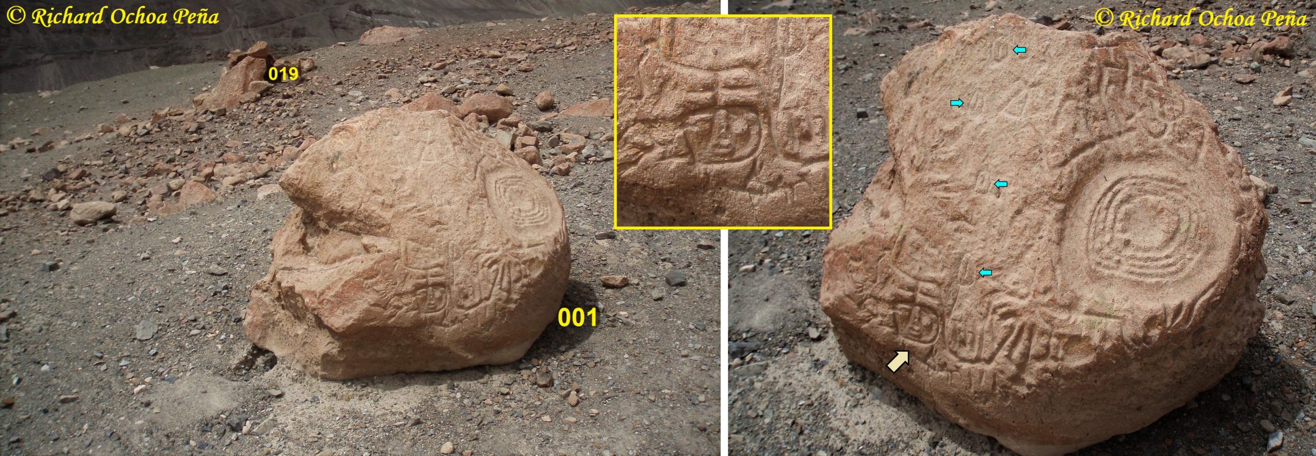
Figure 5. Petroglyphs on Boulder COR-001 at Coropuro, southern Peru. Photographs © by Richard Ochoa Peña – SACRUN SAC (Arequipa).
Remarkable are two large anthropomorphic figures on Boulder COR-009, both with raised arms ending in large hands. Notice the probably older figures of birds and other images that are superimposed by the anthropomorphic petroglyphs (Figure 6). On Boulder COR-021 is a similar anthropomorphic petroglyph (see Figure 8A). Boulder COR-012 has some very deep, parallel grooves (Figure 7A) that may be compared with similar parallel grooves on Panel ROS-024A at Rosario, northern Chile (100 km south of Coropuro). Another panel on COR-012 has several footprints of birds (Figure 7B). Also the long, triangular petroglyph on Boulder COR-008 is remarkable. Because of the appendages it may well be biomorphic. An anthropomorph on the same panel of Boulder COR-008 (unfortunately less clearly visible on the photograph by Richard Ochoa) seems to be repeated on Boulder MIN-054 at Miculla-North.

Figure 6. Petroglyphs on Boulder COR-009 at Coropuro, southern Peru. Photograph © by Richard Ochoa Peña – SACRUN SAC (Arequipa).

Figure 7. A and B: Petroglyphs on Boulder COR-012 at Coropuro, southern Peru. Photographs A and B © by Richard Ochoa Peña – SACRUN SAC (Arequipa). Inset: Detail of Boulder ROS-024A at Rosario, northern Chile. Photograph © by Maarten van Hoek.
On boulder COR-015 is only one petroglyph. It depicts a fully laterally depicted and fully pecked zoomorph (a feline?) with dots for claws. Opposite the small boulder COR-009 is a very large boulder (COR-021) with a rather rough surface. It has a large number of petroglyphs among which are a few anthropomorphs and camelids. Remarkable however are at least four petroglyphs that represent the Insignia-Tumi (orange arrows in Figure 8A). They look like footprints of a bird, but I have demonstrated that they are representations of high-status objects, possibly worn on the head or on garments (Van Hoek 2016). A similar motif occurs on Boulder COR-016 and another one on Boulder COR-009 (orange arrow in Figure 8). Petroglyphs of the Insignia-Tumi occur in a rather wide area, for instance at San Antonio in the Yarabamba Valley of Arequipa, southern Peru, 160 km to the NW (Van Hoek 2017) and at the site of Chilpe in the Azapa Valley of northern Chile (130 km to the SSE) (orange inset in Figure 8). On Boulder COR-029 are also two simple petroglyphs of the Outlined Cross, also known as the “Venus Cross” (yellow arrows in Figure 8A). Boulder COR-019 is remarkable for bearing two petroglyphs of animal tracks and a rather complex anthropomorphic figure (Figure 8B).

Figure 8. A: Boulders COR-009, 021 and 022 at Coropuro, southern Peru. B: Petroglyphs of animal tracks on Boulder COR-019. Photographs A and B © by Richard Ochoa Peña – SACRUN SAC (Arequipa). Orange Inset: Petroglyph of one of the Insignia-Tumis at Chilpe, northern Chile.
Finally, there is proof that the site of Coropuro was also frequented by Post-Columbian travellers as is evidenced by the petroglyphs of crosses on altars on Boulder COR-018 (Figure 9). Similar crosses have been recorded at Alto de Pitis and Toro Muerto in the Majes Valley.

Figure 9. Boulder COR-018 at Coropuro, southern Peru, with Christian Crosses on altars. Photograph © by Richard Ochoa Peña – SACRUN SAC (Arequipa).
At the moment only three rock art sites have been recorded in the drainage of the Río Sama: Coropuro, Quebrada Gil (also known as Coruca) some 29 km to the SW of Coropuro, and the rock art site of Anajiri, 24 km to the east of Coropuro. All three sites belong to the same rock art tradition and most likely indicate an ancient route from the coast to the highlands (and vice versa). So far no examples of geoglyphs have been recorded in the Sama drainage, but just possibly very near the petroglyph site of Coropuro one geoglyph may have been constructed.
*
The Possible Geoglyph at Coropuro
Because geoglyphs (not a form of rock art) are usually very large, many can easily be recognised with the aid of Google Earth. This way I discovered a geoglyph in the Nepeña drainage in northern Peru (Van Hoek 2015) and with Google Earth I could locate the Huacán geoglyphs in the Majes drainage of southern Peru (Van Hoek 2021b). When trying to locate the Coropuro petroglyphs, I also spotted a remarkable feature about 250 m WSW of the petroglyph site. It is found just below an ancient path that runs from east to west. The purported geoglyph runs vertically uphill. Moreover, the lower end ends abruptly (the upper end is blurred). Therefore it is very unlikely that the structure is a road, like the geoglyph at Cíceras in the Majes drainage (Van Hoek 2021a). The structure comprises two narrow, parallel walls (roughly 5 to 6 m apart) of about 20 m in length (possibly longer), located between 1845 and 1865 m asl (Figure 1). The lower, north end of the purported geoglyph is about 285 m south of the valley floor of the Río Sama (at that point at 1795 m asl). Unfortunately the layout of the upper (southern) end of the structure is obscured by debris, possibly caused by minor landslides. Importantly, it seems that the two walls have a small curved end at the lower end. Especially these curved features seem to offer a clue as to the nature of the purported geoglyph.
*
The Geoglyph – Petroglyph Connection at Coropuro
Despite the huge difference in size and in layout there still may exist a link between the Coropuro geoglyph and some of the nearby petroglyphs. Notably two anthropomorphic petroglyphs show characteristics that seem to mimic the geoglyph (or vice versa, of course). In rock art sizes are often exaggerated. For instance, the anthropomorphic figures on Boulder COR-009 have short legs, but one has an exaggeratedly long neck (see Figure 4). However the “strange” Anthropomorph 1 on Boulder COR-004 has extremely long legs that – moreover – both end in curved features that most likely represent the feet (Figure 10A). It has a small, fully pecked head and apparently only one arm (?) that touches (unfinished?) Anthropomorph 2. The long groove between the legs (too long to symbolise male sex? or an unfinished feature?) is still enigmatic. Just possibly the long groove is the body (without legs), while the two long lines might represent excessively long arms. However, this careful suggestion is contradicted by the anthropomorphic figure on Panel COR-008.
Even more interesting is the anthropomorph on Panel COR-008 (Figure 10B). It has a square, outlined head and two curved arms that seem to end in a cupule. Above the head is an undulating line that may represent some kind of headgear (or hair?). The figure seems to have no thorax, but from the shoulders run two long parallel grooves that both end in curved features that – again – most likely represent the feet. I very tentatively would like to suggest that the extremely long legs of those two anthropomorphic figures may be related to the very long lines of the geoglyph, which might represent the legs (and feet) of an intended anthropomorphic geoglyph. The thorax and head may never have been finished or have been blurred by debris.
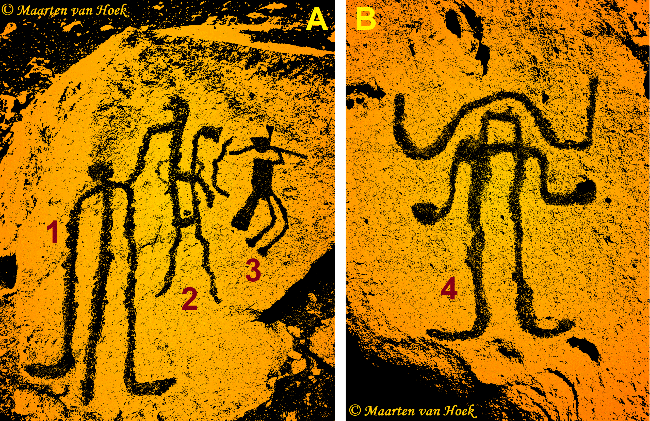
Figure 10. A: Petroglyphs on Boulder COR-004 at Coropuro, southern Peru. B: Petroglyphs on Boulder COR-008 at Coropuro, southern Peru. Drawings © by Maarten van Hoek, based on photographs published by Richard Ochoa Peña – SACRUN SAC (Arequipa).
*
Conclusions
The petroglyphs so far recorded at Coropuro are of interest as they unambiguously confirm their relationship with the rock art tradition in this part of southern Peru and northern Chile. Especially the “flute-player” on Boulder COR-004 is key in this respect. Also the style of the camelid petroglyphs is similar to those at many other sites of this rock art tradition.
Whether the geoglyph indeed was once intended to represent an anthropomorphic feature is most uncertain at this stage, but the resemblance with the long legs of the anthropomorphic petroglyphs on Boulders COR-004 and COR-008 is striking. Scientific research regarding the geoglyph will be necessary in order to establish the possibly anthropomorphic nature of the structure.
*
Acknowledgement
The author is much indebted to archaeologist Richard Ochoa Peña, gerente general of SACRUN-SAC (Arequipa, Perú) for his kind permission to use his photographs in this article. However, the content of this study is completely my responsibility.
![]()
Petroglifos y un Nuevo Geoglifo en el Valle de Sama
Tacna, Peru
Maarten van Hoek
Introducción
Es un hecho que, especialmente en los desiertos costeros del sur de Perú y el norte de Chile (un área también conocida como el Desierto de Andes), los sitios de petroglifo y los sitios de geoglifos a veces se encuentran relativamente juntos en la misma área. Un buen ejemplo es el geoglifo en Cíceras en la cuenca de Majes en el sur de Perú, que se encuentra a solo 940 m (como el ave vuela) al este del sitio del petroglifo de Cíceras (Van Hoek 2021a). Además, los geoglifos y los petroglifos ocasionalmente muestran el mismo tipo de imágenes, como los camélidos en Cíceras, que reflejan varios petroglifos de camélidos en el sitio cercano de Cíceras, y los geoglifos de Huacán (también en la cuenca de Majes, que son muy similares a los petroglifos en Toro Muerto (Van Hoek 2021b). Intentando localizar un sitio con petroglifos cerca de Coropuro en el valle de Sama en el Sur Perú con Google Earth, también noté una gran función cerca el sitio con petroglifos, que posiblemente representa un geoglifo previamente desconocido. Este estudio propone tentativamente que el supuesto geoglifo tenga posibles paralelos en las imágenes del sitio de arte rupestre cercano de Coropuro (Figura 1).
Figura 1. La ubicación del supuesto geoglifo en Coropuro (marco ovalado; ampliado en el recuadro a la derecha) y la ubicación aproximada del sitio de petroglifos de Coropuro (marco rectangular). Ilustraciones © de Maarten van Hoek, basadas en Google Earth.
Los Petroglifos de Coropuro
A unos 85 km del interior desde el pueblo de Boca del Río, en la costa del Pacífico del Sur Perú (ya más de 100 km, cuando siguió el curso del Río Sama) arqueólogo Richard Ochoa Peña – SACRUN SAC (Arequipa) grabó el sitio de Coropuro en las pendientes más bajas de Cerro Resbaladero en el valle de Sama. Más al sur de Cerro Resbaladero, la cumbre de Cerro Caquilluco forma el punto más alto en el área inmediata a 3890 m. Al oeste del sitio, hay el profundo barranco de Quebrada Cobaya. Las laderas de Cerro Resbaladero están completamente despachadas de vegetación (Figura 2), pero están aferradas a escombros, fragmentos de rocas más pequeños y algunas bloques más grandes de piedra volcánica roja, que fueron el objetivo de las personas prehistóricas que crearon sus imágenes en las superficies de las rocas.
Figura 2. Vista desde el sitio de petroglifos de Coropuro, mirando hacia el este. Note el camino antiguo. Las rocas de petroglifos se encuentran en el área de arena gris en primer plano. Fotografía © Richard Ochoa Peña – SACRUN SAC (Arequipa).
Este sitio remoto no se menciona en el inventario compilado por Rainer Hostnig (2003). Pero en una publicación sobre Miculla (un extenso sitio con petroglifos en el extremo sur de Perú), Gordillo Begazo menciona que hay registros (versiones orales) de sitios con petroglifos en el valle de Sama a lo largo de una pista que conecta Coruco (también conocido como Quebrada Gil; a 850 m) con Chucatamani a las 2400 m (1992: 57, 60; exactamente el mismo texto y mapa aparecen en Gordillo Begazo 1996: 99, 102), pero no más detalles, como un nombre del sitio, estaban disponibles. Finalmente, el nombre del sitio petroglifo de Coropuro solo es mencionado por Gordillo Begazo (2004: 344).
Coropuro es un gran campo de roca situado a una altitud promedio de 1845 m, mientras que la llanura aluvial del Valle del Río Sama al norte (alrededor de 215 m) es de 1790 m. Se desconoce cuántas rocas se han registrado, pero según las fotografías publicadas por Richard Ochoa, estimamos tentativamente que hay alrededor de veinte a treinta rocas con petroglifos.
Las imágenes de Coropuro definitivamente pertenecen a la tradición de arte rupestre del sur de Perú (su límite más septentrional es la cuenca de Locumba) y el norte de Chile (su límite más al sur es la cuenca de Camarones). Por ejemplo, los petroglifos de camélidos (totalmente picotados) en Bloque COR-008 (Figura 3A) muestran la misma postura y la típica cola curvado hacia abajo como varios petroglifos de camélidos en Miculla, a 45 km hasta el SSE.
Figura 3. A: Petroglifos de tres camélidos en Bloque COR-008 en Coropuro, sur de Perú. B: Petroglifos de Miculla, sur de Perú. A: Dibujo © de Maarten van Hoek, basado en una fotografía por Richard Ochoa Peña – SACRUN SAC (Arequipa). B: Fotografía © de Maarten van Hoek.
Pero especialmente el petroglifo del perfil supuesto “flautista” en Bloque COR-004 (Figura 4; también ver Figura 10A-3) es casi idéntica a varias imágenes de “flautistas” en el área, por ejemplo, en Bloques MIN-033, MIN -046 y MIN-055 en Miculla-Norte. El “flautista” de Coropuro tiene las patas típicas flexionadas y la cabeza flotante que está claramente separada del cuerpo. El gran apéndice del área genital no representa al sexo masculino, aunque unos pocos petroglifos de “flautistas” en Miculla muestran sexo masculino más un segundo apéndice. Este (segundo) apéndice de la “flautista” es parte de una prenda que es típica de esta tradición de arte rupestre. Además, el tocado (?) del antropomorfo en Bloque COR-008 se puede reflejar en Bloque MIM-014 en Miculla-Midio.
Figura 4. A: Ubicación de Bloque COR-004 (17°28’55.21″S y 70°15’20.07″O en Google Earth 2011) en Coropuro, sur de Perú, mirando al sur hacia Cerro Resbaladero. B: Primer plano del panel. Fotografías © de Richard Ochoa Peña – SACRUN SAC (Arequipa).
Por supuesto, como muchos sitios de arte rupestre, Coropuro también tiene sus especialidades. Especial, y probablemente único, es la gran depresión en forma de cuenco central en Bloque COR-001 que está rodeada por cuatro círculos estrechos y un quinto anillo profundamente empotrado (Figura 5). En el mismo panel hay un petroglifo profundamente tallado que parece representar una cabeza humana. Debido al surco en forma de T emergiendo desde la parte superior de la cabeza, puede ser una cabeza “trofeo” (flecha más grande e inserción en la Figura 5). Finalmente, Bloque COR-001 tiene una fila de cuatro pequeños petroglifos que posiblemente pueden simbolizar las vulvas (indicadas por las flechas pequeñas en la Figura 5).
Figura 5. Petroglifos en Bloque COR-001 en Coropuro, sur de Perú. Fotografías © de Richard Ochoa Peña – SACRUN SAC (Arequipa).
Son notables dos grandes figuras antropomórficas en Bloque COR-009, ambas con brazos levantados que terminan en manos grandes. Observe las figuras probablemente más antiguas de aves y otras imágenes superpuestas por los petroglifos antropomórficos (Figura 6). En Bloque COR-021 hay un petroglifo antropomórfico similar (Figura 6). Bloque COR-012 tiene algunos surcos paralelos muy profundos (Figura 7A) que pueden compararse con surcos paralelos similares en el Panel ROS-024A en Rosario, norte de Chile (100 km al sur de Coropuro). Otro panel en COR-012 tiene varias huellas de aves (Figura 7B). También es notable el petroglifo triangular largo en Bloque COR-008. Debido a los apéndices, bien puede ser biomórfico. Un antropomorfo en el mismo panel de Bloque COR-008 (desafortunadamente menos claramente visible en la fotografía de Richard Ochoa) parece repetirse en Bloque MIN-054 en Miculla-Norte.
Figura 6. Petroglifos en Bloque COR-009 en Coropuro, sur de Perú. Fotografía © de Richard Ochoa Peña – SACRUN SAC (Arequipa).
Figura 7. A y B: Petroglifos en Bloque COR-012 en Coropuro, sur de Perú. Fotografías A y B © de Richard Ochoa Peña – SACRUN SAC (Arequipa). Recuadro: Detalle de Bloque ROS-024A en Rosario, norte de Chile. Fotografía © de Maarten van Hoek.
En Bloque COR-015 hay solo un petroglifo. Representa a un zoomorfo (¿un felino?) completamente representado lateralmente y completamente picoteado con puntos en lugar de garras. Frente al Bloque COR-009 hay un Bloque muy grande (COR-021) con una superficie bastante rugosa. Tiene una gran cantidad de petroglifos entre los que se encuentran algunos antropomorfos y camélidos. Sin embargo, son notables al menos cuatro petroglifos que representan el Insignia-Tumi (flechas naranjas en la Figura 8A). Parecen las huellas de un pájaro, pero he demostrado que son representaciones de objetos de alto estatus, posiblemente usados en la cabeza o en la ropa (Van Hoek 201). Un motivo similar ocurre en Bloque COR-016 y otro en Bloque COR-009 (flecha naranja en la Figura 8). Imagenes de Insignia-Tumi ocurren en un área bastante amplia, por ejemplo en San Antonio en el Valle de Yarabamba de Arequipa, sur de Perú, 160 km al NO (Van Hoek 2017) y en el sitio de Chilpe en el Valle de Azapa en el norte de Chile (130 km al SSE) (recuadro naranja en la Figura 8). En Bloque COR-029 también hay dos petroglifos simples de la cruz delineada, también conocida como la “Cruz de Venus” (flechas amarillas en la Figura 8A). Bloque COR-019 es notable por tener dos petroglifos de huellas de animales y una figura antropomórfica bastante compleja (Figura 8B).
Figura 8. A: Bloques COR-009, 021 y 022 en Coropuro, sur de Perú. B: Petroglifos de huellas de animales en Bloque COR-019. Fotografías A y B © de Richard Ochoa Peña – SACRUN SAC (Arequipa). Recuadro naranja: Petroglifo de uno de los Insignia-Tumis en Chilpe, norte de Chile.
Finalmente, hay pruebas de que el sitio de Coropuro también fue frecuentado por viajeros poscolombinos como lo demuestran los petroglifos de cruces en altares en Bloque COR-018 (Figura 9). Se han registrado cruces similares en Alto de Pitis y Toro Muerto en el Valle de Majes.
Figura 9. Bloque COR-018 en Coropuro, sur de Perú, con cruces cristianas en altares. Fotografía © de Richard Ochoa Peña – SACRUN SAC (Arequipa).
Por el momento sólo se han registrado tres sitios de arte rupestre en la cuenca del Río Sama: Coropuro, Quebrada Gil (también conocida como Coruca) a unos 29 km al SO de Coropuro, y el sitio de arte rupestre de Anajiri, a 24 km al este de Coropuro. Los tres sitios pertenecen a la misma tradición de arte rupestre y muy probablemente indiquen una ruta antigua desde la costa hasta las tierras altas (y vice versa). Hasta ahora no se han registrado ejemplos de geoglifos en la cuenca de Sama, pero posiblemente muy cerca del sitio de petroglifos de Coropuro se pudo haber construido un geoglifo.
El Posible Geoglifo en Coropuro
Debido a que los geoglifos (pero no son una forma de arte rupestre) suelen ser muy grandes, muchos pueden ser reconocidos fácilmente con la ayuda de Google Earth. De esta manera, descubrí un geoglifo en la cuenca de Nepeña en el norte de Perú (Van Hoek 2015) y con Google Earth pude ubicar los geoglifos de Huacán en la cuenca de Majas en el Sur Perú (Van Hoek 2021b). Al intentar localizar los petroglifos de Coropuro, también yo vi una estructura notable a unos 250 m OSO del sitio de Coropuro. Se encuentra justo debajo de un camino antiguo que se extiende de este a oeste. El supuesto geoglifo corre verticalmente cuesta arriba. Además, el extremo inferior termina bruscamente (el extremo superior está borroso). Por lo tanto, es muy poco probable que la estructura sea un camino, como el geoglifo en Cíceras en la cuenca de Majes (Van Hoek 2021a). La estructura comprende dos paredes estrechas y paralelas (aproximadamente de 5 a 6 m de diferencia) de aproximadamente 20 m de longitud (posiblemente más larga), ubicadas entre 1845 y 1865 m (Figura 1). El extremo inferior del norte del supuesto geoglifo es de aproximadamente 285 m al sur de la llanura aluvial del Valle del Río Sama (en ese momento a 1795 m). Desafortunadamente, el diseño del extremo superior (sur) de la estructura está ocultado por escombros, posiblemente causados por deslizamientos leves. Es importante destacar que parece que las dos paredes tienen un extremo curvo pequeño en el extremo inferior. Especialmente, estas características curvas parecen ofrecer una pista sobre la naturaleza del supuesto geoglifo.
La Conexión Geoglifo – Petroglifo en Coropuro
A pesar de la gran diferencia de tamaño y en el diseño, todavía puede existir un vínculo entre el geoglifo de Coropuro y algunos ejemplos de los petroglifos cercanos. En particular, dos petroglifos antropomorfos muestran características que parecen imitar el geoglifo (o vice versa, por supuesto). En el arte rupestre, los tamaños suelen ser exagerados. Por ejemplo, las figuras antropomórficas en Bloque COR-009 tienen piernas cortas, pero una tiene un cuello exageradamente largo (ver la Figura 4). Sin embargo, el “extraño” Antropomorfo 1 en Bloque COR-004 tiene patas extremadamente largas que, además, ambos terminan en características curvas que probablemente representan los pies (Figura 10A-1). Tiene una cabeza pequeña, totalmente picada y, aparentemente, solo un brazo (?) que toca Antropomorfo 2 (¿sin estar terminado?). La ranura larga entre las piernas (¿demasiado larga para simbolizar el sexo masculino o una característica sin estar terminado?) sigue enigmático. Posiblemente, el surco largo es el cuerpo (sin patas), mientras que las dos largas lineas pueden representar brazos excesivamente largos. Sin embargo, esta sugerencia cuidadosa se contradice con la figura antropomorfia en el Panel COR-008.
Figura 10. A: Petroglifos en Bloque COR-004 en Coropuro, sur de Perú. B: Petroglifos en Bloque COR-008 en Coropuro, sur de Perú. Dibujos © de Maarten van Hoek, basados en fotografías publicada por Richard Ochoa Peña – SACRUN SAC (Arequipa).
Aún más interesante es el antropomorfo en el Panel COR-008 (Figura 10B). Tiene una cabeza cuadrada, esbozada y dos brazos curvos que parecen terminar en una cúpula. Por encima de la cabeza es una línea ondulada que puede representar algún tipo de tocado o pelo. El ser humano parece no tener un tórax, sino de los hombros que ejecutan dos ranuras paralelas largas que ambos terminan en características curvas que, nuevamente, lo más probable es que representen los pies. Me gustaría mucha tentativa sugerir que las patas extremadamente largas de esas dos figuras antropomorfas pueden estar relacionadas con las líneas muy largas del geoglifo, lo que podría representar las piernas (y los pies) de un geoglifo antropomorfo previsto. El tórax y la cabeza pueden nunca haber sido terminados o haber sido borrosos por los escombros.
Conclusiones
Los petroglifos hasta ahora registrados en Coropuro son de interés, ya que confirman de manera inequívoca su relación con la tradición del arte rupestre en esta parte del sur de Perú y el norte de Chile. Especialmente el “flautista” en Bloque COR-004 es clave a este respecto. Además, el estilo de los petroglifos de los camélidos es similar a aquellos en muchos otros sitios de esta tradición de arte rupestre.
Si el geoglifo, de hecho, se pretendía representar una característica antropomórfica, es más incierto en esta etapa, pero la semejanza con las piernas largas de los petroglifos antropomorfos en los Bloques COR-004 y COR-008 son sorprendentes. Una investigación científica con respecto al geoglifo será necesario para establecer la naturaleza posiblemente antropomórfica de la estructura.
Agradecimiento
El autor está muy agradecido al arqueólogo Richard Ochoa Peña, gerente general de SACRUN-SAC (Arequipa, Perú) por su amable permiso para utilizar sus fotografías en este artículo. Sin embargo, el contenido de este estudio es completamente de mi responsabilidad.
Traducido con Google Translate – Disculpe cualquier error
Translated with Google Translate – Please excuse any errors
![]()
References – Referencias
Gordillo Begazo, J. P. 1992. Petroglifos y Tráfico: Un caso de Interacción Micro-Regional en el Ámbito de los Valles de Tacna, Perú. In: Boletín de la Sociedad de Investigación del Arte Rupestre de Bolivia. Vol. 6; pp. 54 – 63. Sociedad de Investigación del Arte Rupestre de Bolivia (SIARB), La Paz, Bolivia.
Gordillo Begazo, J. P. 1996. Miculla Petroglifos: La Magia de los Signos. EPF Editores. Tacna, Perú.
Gordillo Begazo, J. 2004. Puesta en valor de los perroglifos de Miculla (Tacna-Peru). In: Actas deI Primer Simposio Nacional de Arte Rupestre (Cusco, noviembre 2004); pp. 341 – 355.
Hostnig, R. 2003. Arte rupestre del Perú. Inventario Nacional. CONCYTEC, Lima, Perú.
Van Hoek, M. 2015. A new geoglyph (?) in Nepeña, Northern Peru. In: Rupestreweb.
Van Hoek, M. 2016. The Frontal Insignia-Tumi: A Rare High-Status Object in Desert Andes Rock Art. In: TRACCE – Online Rock Art Bulletin, Italy. Fully illustrated PDF available at Academia.
Van Hoek, M. 2017. Petroglifos en Yarabamba, Arequipa, Perú: ¿Aplacandos los Apus? In: TRACCE – Online Rock Art Bulletin, Italy.
Van Hoek, M. 2021a. The Cíceras “Carcancha-Bird” Petroglyphs, Majes, Peru. In: TRACCE – Online Rock Art Bulletin, Italy.
Van Hoek, M. 2021b. Contextualising the Geoglyph of Huacán, southern Peru (Spanish version included). In: TRACCE – Online Rock Art Bulletin, Italy.


Leave a Reply