![]() It is known for more than 80 years that the Manga drainage in southern Peru houses one of the most important rock art sites in this part of the Andes (Illomas). However, apart from Illomas there are a number of smaller, yet important rock art sites in this valley. This study discusses two sites in the Manga Valley that were provisionally recorded in 2018 by the Upper Manga Archaeological Survey Project (University of Toronto, Department of Anthropology, Royal Ontario Museum, Canada). It concerns Cuesta de la Pachana and Miraflores-Pachana.
It is known for more than 80 years that the Manga drainage in southern Peru houses one of the most important rock art sites in this part of the Andes (Illomas). However, apart from Illomas there are a number of smaller, yet important rock art sites in this valley. This study discusses two sites in the Manga Valley that were provisionally recorded in 2018 by the Upper Manga Archaeological Survey Project (University of Toronto, Department of Anthropology, Royal Ontario Museum, Canada). It concerns Cuesta de la Pachana and Miraflores-Pachana.
By Maarten van Hoek
*
The Petroglyphs of Cuesta de la Pachana and Miraflores
Manga Valley, Southern Peru
*
Maarten van Hoek
Introduction
Although rock art in the remote and rather isolated Manga Valley and its tributaries (southern Peru) has been known for more than eighty years, it nevertheless remained rather poorly documented until after the year 2000. As early as 1936, Leonidas Bernedo Málaga reported the discovery of a large collection of petroglyphs at Illomas, some of which were first described in the 1940-publication by Paz de Noboa. Illomas is a large and concentrated rock art site with more than 170 decorated boulders, located only 1500 m west of the Upper Manga Valley (Figure 1). Much later, in 2007, Kurt Rademaker and David Reid surveyed the ancient route from the Pacific Coast through the Manga Valley northwards and discovered at least three petroglyph sites (with altogether a minimum of 24 decorated boulders) in the Central Manga Valley (Figure 2), as well as pictographs and petroglyphs in some rock shelters at Cerro Corona Morillo on the high Pampa between the Manga Valley and the Majes Valley further east. Unfortunately, information about any of those Manga sites has not (yet?) been published, but – because Kurt and David shared some data with me – several illustrations and data are available in one of my publications (Van Hoek 2013: 54-55 and 63-64: Figs. 44, 45 and 63).
Click on any illustration to see an enlargement. Click on the enlargement to return to the TRACCE web page.
*
Figure 1: The locations of the three rock art sites discussed in this study. Drawings © by Maarten van Hoek, right-hand map based on Google Earth.

Figure 2: The locations of all known rock art sites in the Manga Valley of southern Peru (up to 2022) and the position of the Manga Valley in-between Toro Muerto and Chillihuay. Map © by Maarten van Hoek; © OpenStreetMap – Contributors.
In 2008 Lorenzo Tacca Quispe published a book about the rock art at Illomas, which included the lavishly illustrated reports of the following rock art sites that he explored in the Upper Manga Valley (without mentioning who discovered or first reported the sites and when): Mollorco; Hacienda Illomas; Segundo Rancho; Capillacucho; Cuesta de Pachana and of course Illomas). In 2018 a team from the University of Toronto, Canada, surveyed the rock art of Illomas (Jennings, Van Hoek et al. 2019) and simultaneously briefly explored the rock art site of Cuesta de la Pachana, which, although called Questa de la Pachana by Jennings, Van Hoek et al. (2019: Fig. 15), has incorrectly been re-named “Pachanga” in my book about the rock art at Quilcapampa in the Sihuas Valley of southern Peru (Van Hoek 2021a: 82). The site name of “Pachanga” in the text and in Figure 74 of my 2021-book should therefore read “Cuesta de la Pachana”. The Canadian team also reported a possibly new site at Miraflores-Pachana, also at the east bank of the valley. Those two rock art sites – Cuesta de la Pachana and Miraflores-Pachana – are the subjects of this study.
Because the petroglyphs of nearby Illomas have already been prefixed “PAJ” (Jennings, Van Hoek et al. 2019: Note 3), I decided to use the prefix of CUP for the rock art complex of Cuesta de la Pachana and the prefix of MPA for the rock art complex at Miraflores-Pachana, in order to avoid confusion. The locations of the three rock art sites are shown in Figures 1 and 2. It must be emphasised that I have not visited any of those sites myself. Therefore, all the results of this study are completely based only on the 184 photographs kindly shared with me by Justin Jennings of the Upper Manga Archaeological Survey Project (University of Toronto, Canada). Consequently, the outcomes of this study (inventories, descriptions, conclusions and my theories) are my responsibility only.
*
Cuesta de la Pachana
The first publication of the petroglyph site of Cuesta de la Pachana is by Lorenzo Tacca Quispe (2008: 37 – 39). The site got this name because – according to Tacca Quispe – the river Manga is called Quebrada de Pachana at this point. Regarding this site Tacca Quispe mentions and illustrates what he calls “doce petroglifos trabajados sobre bloques Ignimbtita o Sillar” (2008). This may present a problem. The number of “twelve” (doce) gives the incorrect impression that twelve “petroglyphs” (images) have been recorded by Tacca Quispe. However, the use of the word “petroglifo” in Spanish publications by Peruvian archaeologists presents an issue regarding establishing the statistics of rock art images and panels. In several cases it proves that – despite the use of the singular – the term “petroglifo” confusingly refers to a decorated panel, which may in fact have numerous images (thus the plural “petroglifos” should consequently – but confusingly – refer to more than one panel). This often proves to be incorrect. This also is the case with the publication by Tacca Quispe. He published 12 illustrations, but not of 12 different panels. For instance, his Fotos 43, 44 and 45 in fact concern two panels (each with more than one petroglyph) found on one and the same boulder (Boulder CUP-005 in this study). Moreover, his twelve illustrations do not show all petroglyphs (see Figures 3A, B, E and F) and Quispe Tacca did not publish illustrations of all the decorated panels recorded in 2018.
Based on the photographic survey carried out by the Upper Manga Archaeological Survey Project (henceforth referred to as the UMASP) the results of which were generously shared with me by archaeologist Justin Jennings of the University of Toronto, Department of Anthropology, Royal Ontario Museum, Canada, I tentatively inventoried the available information in order to present the results as a preliminary record of the site (and thus most likely to be incomplete). Mind you, I only had the photos to go by (none with GPS coordinates) and therefore inaccuracies and/or errors may have occurred.
Because an official scientific survey has never been carried out at Cuesta de la Pachana (nor at Miraflores-Pachana for that matter), there do not exist numbering systems either. For that reason I introduce my own systems of numbering (although I have never visted any of the two sites), in which all boulders are labelled CUP-001 etc. (for Cuesta de la Pachana) or MPA-001 etc. (for Miraflores-Pachana). In case of boulders known to have more than one panel, the capital letters A, B etc. will be added (for instance CUP-001A and B etc.). My “inventory” only offers the very minimum, as there may well be more petroglyphs, or decorated panels or even more decorated boulders than photographed in 2018 by the UMASP. Moreover, in a few cases a panel that has been registered in this study by a certain number (for instance CUP-008) may well represent a panel of a boulder with a different number (like CUP-003) after all. Scales and estimated bearings will only be provided when available.
Probably all decorated boulders at Cuesta de la Pachana are found rather close together at a relatively level area with numerous boulders that once fell from the ridge to the east of the site (see Figures 4, 10 and 11). The centre of this small rock art site is located at an altitude of about 2175 m asl; 290 m above the valley floor, which is about 1000 m to the west. The ascent is rather tiresome and may take up to two hours. The petroglyphs on the following boulders/panels were photographed in 2018 by participants of the UMASP. However, this study will only offer photographs of the better visible petroglyphs.
*
The Petroglyphs of Cuesta de la Pachana
Boulder CUP-001: Large boulder with at least six decorated panels. Panel CUP-001A: (Tacca Quispe 2008: Dib. 20, illustrating only the better recognisable images of Panels CUP-001A and B as one panel; Figure 4). West facing Panel A is almost entirely covered with petroglyphs, including deeply engraved profile birds and quadrupeds, at least two (possibly three) felines and a solar symbol. At the very top is possibly a very faint anthropomorphic figure, while a small ledge just below the top has some other petroglyphs.
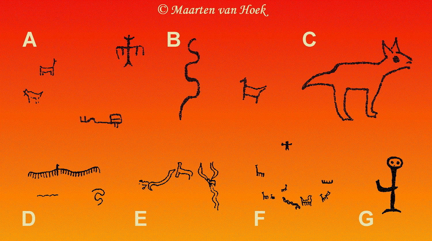
Figure 3: Petroglyphs at Cuesta de la Pachana according to Tacca Quispe (2008). Drawing © by Maarten van Hoek, based on drawings by Tacca Quispe (2008).

Figure 4: Panels CUP-001A and B at Cuesta de la Pachana, Manga. Photographs courtesy of and © by Justin Jennings and the Upper Manga Archaeological Survey Project; University of Toronto, Department of Anthropology, Royal Ontario Museum, Canada.
Panel CUP-001B: SW facing panel with a rough surface, photographed when partially in the shade and for those reasons many petroglyphs cannot be identified. Recognisable are a few quadrupeds, an undulating line, a circle and (often deep) grooves.
Panel CUP-001C: Smooth, south facing panel (possibly illustrated by Tacca Quispe [2008: Dib. 16; see Figure 3B]). Large H-shaped motif composed of thin lines (certainly not a quadruped as suggested by Tacca Quispe ( possibly a stylised anthropomorph?); some small, very simple quadrupeds; an angular meandering line touching (?) a serpentine groove; two possible, very small, fully pecked petroglyphs (at the bottom, just above a wide crack) that could be anthropomorphs or (when viewed as a unity) perhaps an (unfinished?) camelid.
Panel CUP-001D: Rough, SE facing panel, completely in the shade. Only very few petroglyphs that are – moreover – only faintly recognisable. Panel CUP-001E: Large, uneven NE facing panel with (near the bottom) at least one large, outlined and internally decorated quadruped with a “feline-tail” and (possibly) a camelid head, but apparently without legs (Figure 5). One (possibly two) very small, match-stick quadrupeds and a number of indistinguishable lines and motifs (especially halfway-up the panel, where at least one outlined and spotted quadruped is faintly visible). Panel CUP-001F: The slightly west-sloping upper part (atop Panel CUP-001A) faintly shows some petroglyphs (including a match-stick anthropomorph?).

Figure 5: Panel CUP-001E at Cuesta de la Pachana (and detail), Manga. Boulders CUP-002 and CUP-005 are marked. Illomas is visible in the background. Photographs courtesy of and © by Justin Jennings and the Upper Manga Archaeological Survey Project; University of Toronto, Department of Anthropology, Royal Ontario Museum, Canada.
Boulder CUP-002: Visible from Boulder CUP-001 is a long boulder with possibly five decorated panels. Panel CUP-002A: The upper, SW sloping panel has at least three outlined quadrupeds (one unfinished?); one hard to classify biomorph (a frog or an anthropomorph?), a serpentine groove next to another hard to classify biomorph. Panel CUP-002B: (Tacca Quispe 2008: Foto 42). This smooth, SE facing panel features at least seven small, outlined quadrupeds (one unfinished), one match-stick example and – in an isolated position – one possible small, match-stick anthropomorph (Figure 6.1.B). It is possible that the group of quadrupeds (all looking east) is followed (chased?) by an (extremely faintly visible) feline (?). Panel CUP-002C: (Tacca Quispe 2008: Dib. 19, only illustrating some of the images on this panel; see Figure 3E; Figure 6.2.C). On its fractured NE facing surface are several match-stick and outlined quadrupeds (one vertically arranged, as if “jumping”), some arcs and serpentine lines, one match-stick anthropomorph and one large outlined and fully laterally depicted bird. Panel CUP-002D: On this rough NNE facing panel are at least two rather large quadrupeds, the outlines of which have so rather deeply and widely been carved that the untouched parts stand out in relief (Figure 6.2.D). Panel CUP-002E: The lower SW facing panel (immediately below Panel CUP-002A) might have some (extremely faint) petroglyphs (possibly the product of “wishful thinking” from my side).

Figure 6: Panels CUP-002B, C and D at Cuesta de la Pachana, Manga. Photographs courtesy of and © by Justin Jennings and the Upper Manga Archaeological Survey Project; University of Toronto, Department of Anthropology, Royal Ontario Museum, Canada.
Boulder CUP-003: Very large boulder with two panels (both in the shade), both probably facing SSE (Figure 7A). Panel CUP-003A: Large, partially outlined (unfinished?) quadruped with the body composed of three parallel rows of dots (Figure 7B.A1) (similar examples have been reported at Toro Muerto in the Majes Valley further east). To its (lower) right might be the petroglyph of a small anthropomorph (with a rayed headgear?) (Figure 7B.A2). Panel CUP-003B: At least two vertically arranged serpentine lines (not visible in the photo).

Figure 7: Panels CUP-003A and B at Cuesta de la Pachana, Manga. Photographs courtesy of and © by Justin Jennings and the Upper Manga Archaeological Survey Project; University of Toronto, Department of Anthropology, Royal Ontario Museum, Canada.
Boulder CUP-004: (Tacca Quispe 2008: Dib. 21; see Figure 3F). I estimate the bearing of this smooth panel to be SSE. It has – near the top – one small, fully pecked anthropomorph with outstretched arms showing with digits (Figure 8: inset); possibly up to seven quadrupeds (one with a long neck [the quadruped measuring 35 cm in height]); just possibly a very small bird (?) and some grooves (one set of parallel, undulating lines possibly depicting a snake). The lower part is partially covered by a possibly ancient wall (covering more petroglyphs?). Just to the right of the long-necked quadruped (in the shade) may be the roughly pecked image of a petroglyph (an outlined biomorph?).
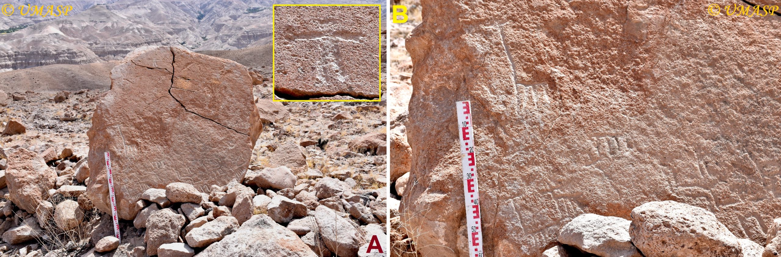
Figure 8: Boulder CUP-004 at Cuesta de la Pachana, Manga. Photographs courtesy of and © by Justin Jennings and the Upper Manga Archaeological Survey Project; University of Toronto, Department of Anthropology, Royal Ontario Museum, Canada.
Boulder CUP-005: Boulder with two decorated panels. Panel CUP-005A: (Tacca Quispe 2008: Foto 44). On its more steeply sloping NE facing surface are one outlined, dotted quadruped; a few curvilinear lines and some very faint lines (see Figure 12A). Panel CUP-005B: (Tacca Quispe 2008: Fotos 43 and 45; Figure 9A). On its almost horizontal, yet still NE facing surface is one large, unusual biomorphic (?) image with an outlined “body” from which seven long grooves emerge (an octopus?; although suggested by Tacca Quispe to depict a water-spring). Another, small complex figure (25 cm in length; Figure 9B) may also represent a biomorph (a cactus?; though tentatively suggested by Tacca Quispe to represent a tree or a religious symbol). There are several more serpentine and straight or parallel (often long) grooves as well as seven ring-marks, most with a centrally placed dot.
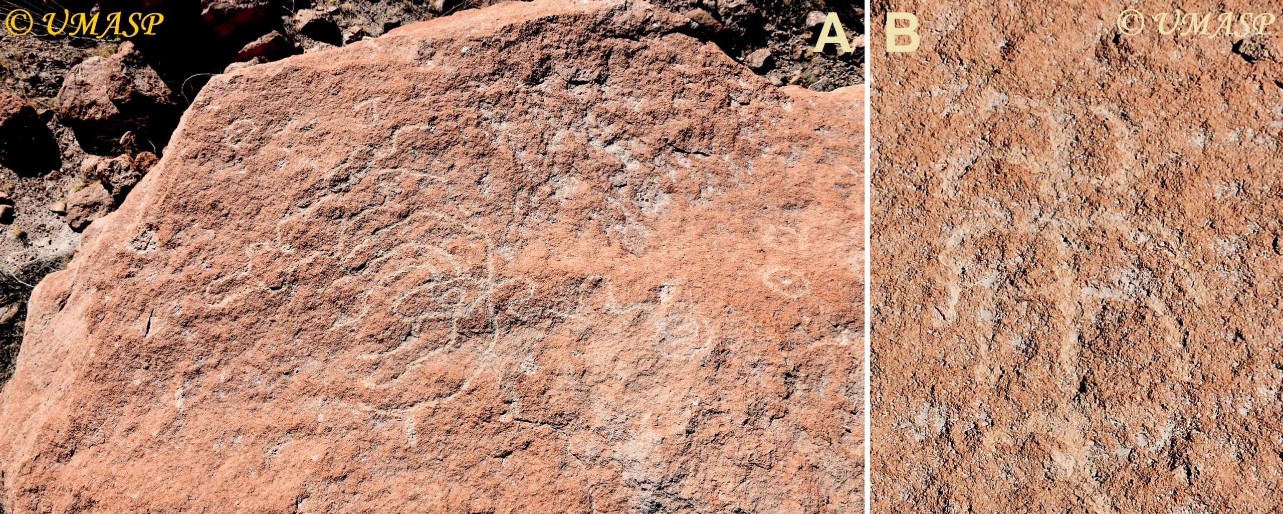
Figure 9: Panel CUP-005B at Cuesta de la Pachana, Manga. Photographs courtesy of and © by Justin Jennings and the Upper Manga Archaeological Survey Project; University of Toronto, Department of Anthropology, Royal Ontario Museum, Canada.
Boulder CUP-006: (Tacca Quispe 2008: Dib. 18; see Figure 3D). Bearing unknown. Panel with at least three petroglyphs including two curvilinear lines and a long, undulating line (its length estimated by me to be 110 cm), from which numerous short, parallel lines run downwards; the whole suggested by Tacca Quispe to represent a bird, possibly even a condor.
Boulder CUP-007: Panel with some very faint (even doubtful) petroglyphs near the top.
Boulder CUP-008: (Tacca Quispe 2008: Dib. 15; Figure 3A; see Figure 3A). Bearing unknown. Mottled, rather rough and weathered panel with a number of barely visible petroglyphs possibly depicting quadrupeds, a frontally depicted biomorph (approximately 26 cm in height) (suggested by Tacca Quispe to represent an anthropomorph, but perhaps depicting a bird?); many more (faint) petroglyphs including at least one rather small, fully frontally depicted match-stick anthropomorph with raised arms (roughly 24 cm in height).
There are possibly two more (panels with?) petroglyphs that I could not either recognise or have not seen among the photographic record of the UMASP. It concerns two drawings by Tacca Quispe (2008: Dib. 17 and Dib. 22) depicting a quadruped (a fox?) (Figure 3C) and an incomplete anthropomorph (Figure 3G).
*
Discussing Cuesta de la Pachana
Although the rock art site of Cuesta de la Pachana is (especially compared with “nearby” Illomas) a very modest one (with possibly up to nine decorated boulders) it is of crucial importance when it comes to explaining the selection of a site for rock art production in this part of Arequipa, Peru. The boulders at Cuesta de la Pachana are located at a spot 2175 m asl and 290 m above the valley floor (which is about 1000 m to the west of the site). However, the ascent to the site from the valley floor involves a 1500 m uphill scramble, which can be rather exhausting because of the often very steep gradients and the often loose rocky or sandy soils. It may take one or two hours to reach the site from the valley. One can therefore wonder why those specific boulders at such a remote and difficult to reach site were frequented by visitors and why rock art was manufactured at that very spot, thus creating a Sacred Site.
The answer has been formulated for the first time by Tacca Quispe (2008: 37) and (later repeated) by Jennings, Van Hoek et al. (2019: 6; Fig. 3). It is also visible in satellite photos (Figure 10). Cuesta de la Pachana is notably located exactly on an ancient route from the Manga Valley to Chuquibamba and the Majes Valley, the latter route most likely leading via the largest rock art site of the Andes, Toro Muerto (30 km to the SE). After having manufactured rock art at Cuesta de la Pachana, travellers continued their journey, either down to the Manga Valley (possibly using a very large, isolated boulder at 2100 m as a point of orientation; Figures 11 and 21), or uphill to the more level Pampa de Incacancha, which they reached at a point 2400 m asl. At that point the route diverged and when travelling south one would ultimately reach the Pacific Coast. However, when travelling north, one first reached the ancient complex of Incacancha with its ruins and several impressive “chullpas” (burial towers) and other structures before continuing further north to Chuquibamba, or SE to Majes (a map of the major trails in the vicinity of Illomas has been published by Jennings, Van Hoek et al. 2019: Fig. 3). Both the rock art site of Cuesta de la Pachana and the complex of Incacancha may have been used as “tambos”, resting places of clearly different nature and date. In this respect it may be important that in the rather level area at Cuesta de la Pachana no ruins of ancient buildings seem to occur.
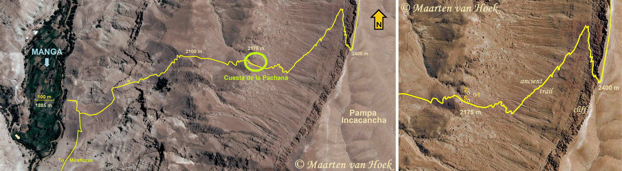
Figure 10: Location of Cuesta de la Pachana on the ancient trail from the Manga Valley to the Majes drainage. Drawings © by Maarten van Hoek, based on Google Earth.

Figure 11: Location of Cuesta de la Pachana on the ancient trail from the Manga Valley to the Majes drainage viewed from above. Only one decorated boulder – CUP-002 – is visible, as is the isolated boulder (at 2100 m asl) immediately north of the trail, which continues across the white promontory (marked “W”, also in Figure 10). Photograph courtesy of and © by Justin Jennings and the Upper Manga Archaeological Survey Project; University of Toronto, Department of Anthropology, Royal Ontario Museum, Canada.
Also the imagery at Cuesta de la Pachana reflects a long use as resting place, as well as being an intermediate site between Toro Muerto and Illomas. Both at Illomas and at Toro Muerto the same array of images is found (belonging to the Majes Rock Art Style [MRAS]; see Van Hoek 2018), firmly confirming the physical and spiritual connection between the three sites. One example – in my opinion – demonstrating the relationship between Toro Muerto and Cuesta de la Pachana is the outlined quadruped on Panel CUP-005A (Figure 12A; see also Figure 3C), which looks much like the petroglyph on Panel TM-Dx-073 at Toro Muerto (which, however, has no internal dots) (Figure 12B and C). However, the best examples of typical MRAS images at Cuesta de la Pachana (involving a collection of typical MRAS birds and quadrupeds) are found concentrated on Panel CUP-001A (see Figure 4).

Figure 12A: Panel CUP-005A at Cuesta de la Pachana, Manga. Photograph courtesy of and © by Justin Jennings and the Upper Manga Archaeological Survey Project; University of Toronto, Department of Anthropology, Royal Ontario Museum, Canada. B and C: Boulder TM-Dx-073 at Toro Muerto. Photographs © by Maarten van Hoek.
Importantly, the whole rock art complex of Illomas is clearly visible from Cuesta de la Pachana, 2700 m to the west, across the Manga Valley (see Figures 5, 14A and 21). Yet, visibility of Illomas was not the desired goal when selecting this spot for rock art production (perhaps it merely was some sort of appreciated bonus, afterwards). The main reason why precisely this spot on the route was selected for rock art production, is because the area is strewn with numerous suitable boulders (see Figure 11), often with a reddish-brown patina (a preferred colour in Andean worldview; see Van Hoek 2015). The site thus became a resting place for travellers (long before Wari and Inca arrived in this part of Arequipa). Concluding, Cuesta de la Pachana is a Sacred Site; a religious resting place on the ancient route from Majes to Manga.
However, I am convinced that most of the iconography and its religious and spiritual content travelled as a team from Majes to Manga, not vice-versa. In this respect it is also important to notice that the image of the feline (also present at Cuesta de la Pachana and at Miraflores-Pachana) is overabundant in the rock art region around Illomas (Tacca Quispe 2008: especially 80-86; Jennings, Van Hoek et al. 2019). This distribution reflects the overrepresentation of felines in the Central Majes Valley, where one of my studies established that feline imagery is found truly overrepresented at Toro Muerto and Alto de Pitis (Van Hoek 2021b).
*
Miraflores-Pachana
Strikingly, when compared with the rock art site of Cuesta de la Pachana (located at 2175 m asl), the situation at Miraflores-Pachana is completely different, certainly when it comes to the location (Figure 13). First of all, the site (located at 1830 m to about 1840 m asl) is found on a rather level area only five to about twenty meters above the valley floor (at that point at 1825 m asl). Unfortunately, it is unknown to me exactly where four or five (of the possibly ten or eleven) decorated boulders are located.

Figure 13: The rock art site of Miraflores-Pachana, Manga. Photographs courtesy of and © by Justin Jennings and the Upper Manga Archaeological Survey Project; University of Toronto, Department of Anthropology, Royal Ontario Museum, Canada.
Because of its very low altitude, views are limited in most directions and consequently no other rock art sites have yet been reported to be visible from Miraflores-Pachana. Illomas is definitely invisible (Figure 14B). Yet, the selection of this site may be intentional as well, as it may be connected with a large area immediately north of the rock art site. It is an extensive, rather level area, also on the east bank, stretching for about 450 m from south to north. It features the numerous ruins of a settlement comprising different types of buildings (possibly of different ages as well). It is thus possible that the people residing in that area intentionally selected the site of Miraflores-Pachana for rock art production, which thus also became a Sacred Site. But there is a huge difference, as will be demonstrated.

Figure 14: Profiles across the Manga Valley. A: Cuesta de la Pachana; B: Miraflores-Pachana. Drawings © by Maarten van Hoek, based on Google Earth.
*
The Petroglyphs of Miraflores-Pachana
As far as I know, the rock art site of Miraflores-Pachana was recorded for the first time by the team of the Upper Manga Archaeological Survey Project (UMASP) in 2018. Again, the following “inventory” only offers the very minimum, as there may well be more petroglyphs, or decorated panels or even more decorated boulders than photographed in 2018 by the UMASP. In a few cases a panel that has been registered in this study by a certain number (for instance MPA-006) may well represent a panel of a boulder with a different number (like MPA-002) after all. Scales are provided when available, but the exact bearings of the several panels are unknown to me, and thus bearings have been estimated.
Boulder MPA-001: On the (almost) vertical, east facing panel of a large, fractured boulder are at least four petroglyphs (Figure 15) depicting simple, match-stick quadrupeds (most likely camelids) all looking downstream (south). Location: -16.037736° and -72.720036° (at 1836 m asl); just north of a shallow gully and only 105 m east of the eastern edge of the valley floor.

Figure 15: Boulder MPA-001 at Miraflores-Pachana, Manga. Photograph courtesy of and © by Justin Jennings and the Upper Manga Archaeological Survey Project; University of Toronto, Department of Anthropology, Royal Ontario Museum, Canada.
Boulder MPA-002: On three roughly SE facing panels of this large boulder are altogether five petroglyphs of match-stick quadrupeds (again, most likely camelids), looking in different directions (Figure 16A). One quadruped has a smaller “something” (a young?) between its legs. The largest quadruped measures 27 cm in height. Immediately south of Boulders MPA-002 and neighbouring 003 are the ruins of an (ancient?) rectangular structure of small boulders, of which the two large boulders form the north wall. Location of both boulders: – 6.037368° and -72.720620° (at 1829 m asl), only 40 m east of the eastern edge of the valley floor.

Figure 16A: Boulder MPA-002 and B: Part of Boulder MPA-004 at Miraflores-Pachana, Manga. Photographs courtesy of and © by Justin Jennings and the Upper Manga Archaeological Survey Project; University of Toronto, Department of Anthropology, Royal Ontario Museum, Canada.
Boulder MPA-003: Touching Boulder MPA-002 is Boulder MPA-003, which has two panels. Panel MPA-003A: The SW facing panel has at least one poorly executed petroglyph of a quadruped (a camelid?) that is looking to the right. It measures about 15 cm in width. Panel MPA-003B: The NW sloping, upper surface of the boulder seems to have (two?) parallel running rows of small markings (the wings of a bird?). Same location as Boulder MPA-002.
Boulder MPA-004: On this small boulder are the rather deeply carved, match-stick petroglyphs of two confronting quadrupeds (camelids?) and (above this ensemble, which measure 25 cm in height) are three more, smaller and more superficially executed match-stick quadrupeds (camelids?). Just below the ensemble (Figure 16B) are some rather deep grooves (an attempt to manufacture another quadruped?). This boulder is located very near Boulder MPA-007.
Boulder MPA-005: This boulder has two decorated panels (Figure 17). Panel MPA-005A: The west facing panel has possibly up to ten petroglyphs of quadrupeds (all camelids?) one of which has a smaller animal between the legs (a young?), while another example is looking backwards. Two of those ten examples seem to have been unfinished. Surrounding a centrally placed and very complex (abstract?) petroglyph are at least four smaller petroglyphs that cannot be easily classified. Panel MPA-005B: The south facing panel shows at least two rather roughly executed, match-stick petroglyphs depicting quadrupeds (again, most likely camelids), one of which (the larger: measuring about 20 cm in height) seems to have six legs. The smaller quadruped seems to be unfinished. Location: -16.036969° and -72.719792° (1844 m asl); on the north bank of a narrow quebrada and diagonally opposite Boulder MPA-007; about 160 m east of the eastern edge of the valley floor.
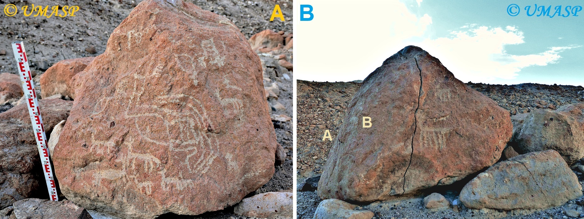
Figure 17: Boulder MPA-005 at Miraflores-Pachana, Manga. Photographs courtesy of and © by Justin Jennings and the Upper Manga Archaeological Survey Project; University of Toronto, Department of Anthropology, Royal Ontario Museum, Canada.
Boulder MPA-006: Based on the sequence of the photographic record it is certain that this panel is located not far from Boulder MPA-002. But how far? In fact, the decorated surface could even be the WNW facing panel of Boulder MPA-002, but this could not be corroborated by me with certainty. Also members of the UMASP did not have a recollection of its location (Justin Jennings 2022: pers. comm.). However, the three photos of Panel MPA-006 that were provided by the UMASP were all taken from (very) close-by, as if it was not possible to step away from the panel. In this respect it may also be telling that the WNW face of Boulder MPA-002 directly overlooks the steep and rocky slope of the east bank of the River Manga, just east of the panel (see “6” in Figure 13B). If the felines are indeed on this panel, it will undeniably be difficult or even impossible to photograph the panel from a distance. Moreover, if indeed on this panel of Boulder MPA-002, the petroglyphs will go unnoticed to people passing by.
The panel (Figure 18) shows the outlined petroglyphs of two decorated felines (about 100 cm above the present soil level). Both are oriented in the same direction (north?). The smaller feline measures 33 cm across and has its face turned towards the observer of the panel (which is standard in MRAS felines). The larger may measure up to 50 cm in width, but because its head is rather indistinct (blurred because of weathering or perhaps because of intentional prehistoric obliteration?) its actual size could not precisely be established. There is also at least one small petroglyph of a match-stick quadruped (a camelid?).
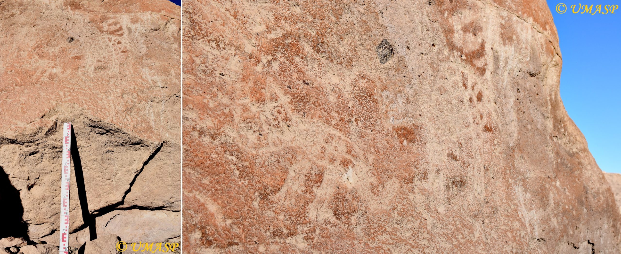
Figure 18: Boulder MPA-006 (MPA-002?) -at Miraflores-Pachana, Manga. Photographs courtesy of and © by Justin Jennings and the Upper Manga Archaeological Survey Project; University of Toronto, Department of Anthropology, Royal Ontario Museum, Canada.
Boulder MPA-007: This large boulder has a number of undulating surfaces that will be treated here as one (mainly upward facing) panel (Figure 19A). It has one large concentric set of irregular rings (estimated to be about 35 cm across) and a similar, smaller set. There are at least three (perhaps four) match-stick petroglyphs of quadrupeds (most likely camelids; Figure 19B) and some (long) grooves (one ending in a cupule). Location: -16.036989° and -72.719884° (1843 m asl); on the south bank of a narrow quebrada (and opposite Boulders MPA-005 and MPA-008); about 147 m east of the eastern edge of the valley floor.
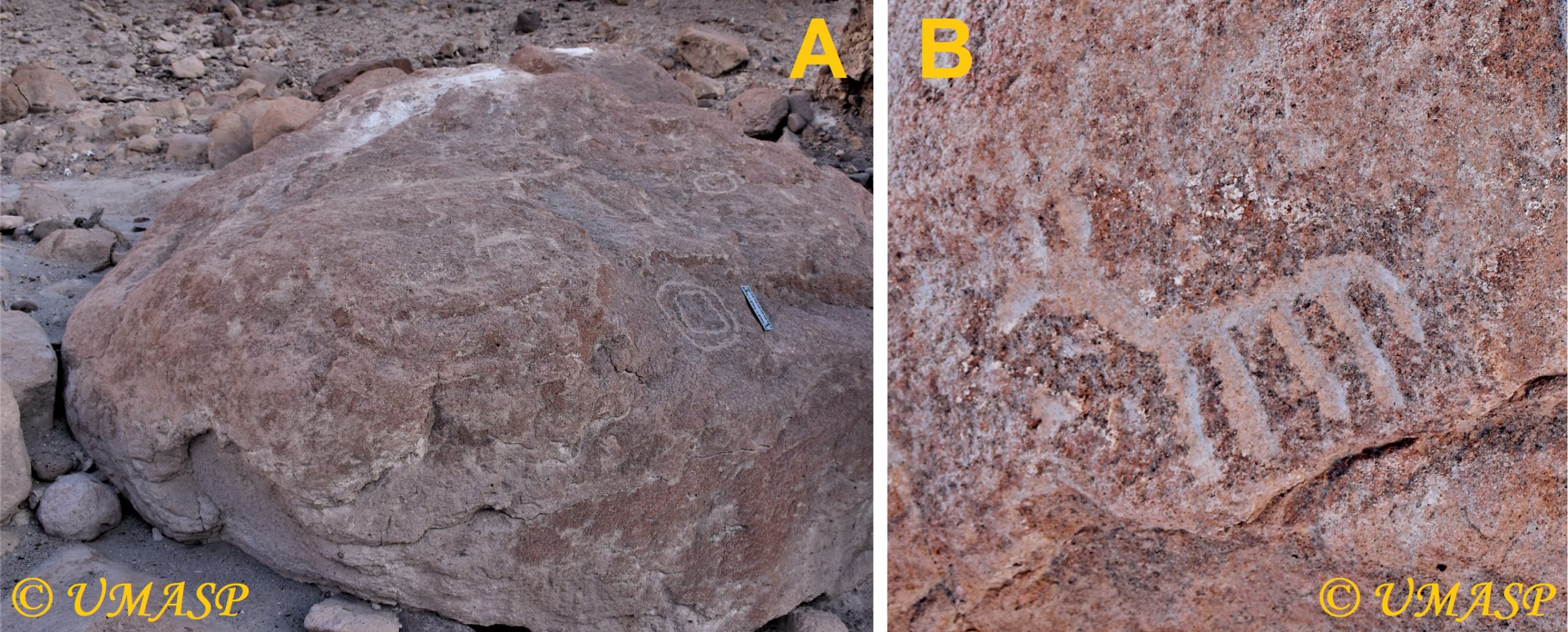
Figure 19: Boulder MPA-007 at Miraflores-Pachana, Manga. Photographs courtesy of and © by Justin Jennings and the Upper Manga Archaeological Survey Project; University of Toronto, Department of Anthropology, Royal Ontario Museum, Canada.
Boulder MPA-008: Boulder with at least one match-stick petroglyph of a quadruped (camelid?) measuring about 15 cm across and a set of four straight grooves (three running parallel; an unfinished quadruped?). This boulder (Figure 20) rests against Boulder MPA-005 (which is located at: -16.036969° and -72.719792° (1844 m asl); on the north bank of a narrow quebrada and opposite Boulder MPA-007.
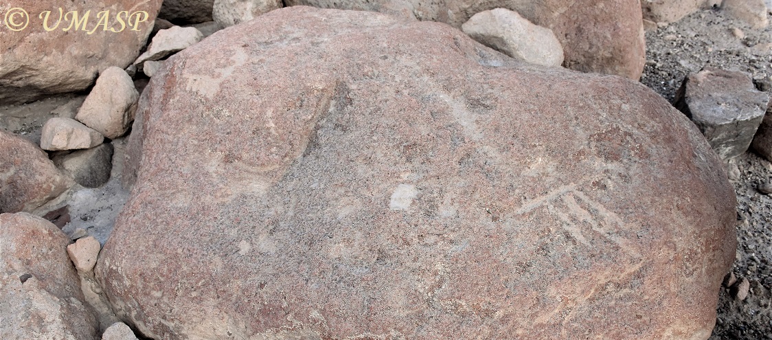
Figure 20: Boulder MPA-008 at Miraflores-Pachana, Manga. Photograph courtesy of and © by Justin Jennings and the Upper Manga Archaeological Survey Project; University of Toronto, Department of Anthropology, Royal Ontario Museum, Canada.
Boulder MPA-009: Boulder with petroglyphs of two quadrupeds, the smaller (with only three legs) above the larger, which measures 20 cm across. The smaller looks like being an unfinished quadruped, especially when compared with the unfinished (?) example on Boulder MPA-008. This boulder may be located somewhere between Boulder MPA-003 and MPA-007.
Boulder MPA-010: Boulder with a set of faint grooves that – just possibly – may include a match-stick quadruped.
Panel MPA-011: Panel with a set of faint grooves that cannot be classified. This panel possibly is part of either Boulder MPA-002 or 003.
*
Discussing Miraflores-Pachana
What is most important when comparing the imagery of Miraflores-Pachana with Cuesta de la Pachana (and with Illomas, for that matter) is that the great majority of the images at Miraflores-Pachana comprises only simple, match-stick petroglyphs of quadrupeds, which most likely all depict camelids. No less than 35 examples – all almost similarly executed – have been counted by me at Miraflores-Pachana. This strongly contrasts with the statistically rather poor repertoire of the few petroglyphs depicting other images at Miraflores-Pachana, which comprise a few (mainly simple) abstract motifs (like circles and some grooves) and – importantly – two felines.
Because the two petroglyphs depicting felines strongly resemble the many images of felines at other rock art sites in the Manga area (Illomas, Hacienda Illomas; Segundo Rancho; Capillacucho and Cuesta de la Pachana; see Tacca Quispe for illustrations), I tentatively would like to suggest that it is possible that an artist – a foreigner to the nearby settlement? – visited the site and left her or his exclusive marks. Those felines may well represent the very first marks at this spot, as I consider the imagery of the MRAS to be older than the simple match-stick petroglyphs of camelids. He or she may well have transported the mind-image of the feline from the east (Majes) or north (Illomas etc.) further to the south, where it appears again (yet only once) on a huge boulder at Quebrada de Manga 2 (see Figure 2 for location; Van Hoek 2013: Fig. 44; feline barely visible). This remote boulder is located about 14.3 km due south of Miraflores-Pachana (at -16.165943° and -72.716794° and at 1455 m asl) (data based on information kindly supplied by Kurt Rademaker and David Reid).
However, because of the extremely limited array of images at Miraflores-Pachana, I also tentatively suggest that this rock art site was mainly frequented by local people, possibly only from the settlement directly to the north of the site. Those local visitors manufactured images of what was important to them: quadrupeds, or perhaps better voiced: camelids. The fact that at least two decorated boulders are part of a structure of what seems to be a camelid-pen (while a few other possible camelid-pens are found nearby) seems to confirm a purely local origin for (most of) the rock art at Miraflores-Pachana. The relation with camelids may also be evidenced by the numerous very narrow trails of camelids north of the gully with Boulders MPA-002, 003, 005, 007 and 008 that converge at a point only 38 m east of Boulder PMA-005, where clearly an ancient track crosses the gully. The trails and track continue further south. Perhaps they represent an ancient route leading further south through the Manga Valley. Possibly the track once connected Miraflores-Pachana with the rock art sites further south in the valley.
*
General Conclusions
This study demonstrates that the reasons to create rock art at a specific spot can be different, even though most (if not all) rock art sites are Sacred Sites (and should respectfully be treated as such). It must be emphasised however that the distinction between those rationales are not always clear-cut. Yet, it is possible to distinguish three types of reasons that explain why rock art was being manufactured at a certain spot.
I would like to start with Illomas with its numerous decorated boulders (and even more decorated panels, many of which are crowded with – often large and impressive – petroglyphs). First of all it is evident that statistically the number of images is enormous. Secondly and importantly, there is a huge variation in images, at least when compared with all known rock art sites in the Manga drainage (Tacca Quispe 2008; Jennings, Van Hoek et al. 2019). Thirdly and most importantly, Illomas is not located on one of the ancient trails that criss-cross the landscape.
The ancient trail that descends from Cuesta de Pachana (Figure 21) crosses the Manga Valley just north of the confluence of the Manga river and the Quebrada de Illomas (indicated by a grey arrow in Figure 10) and continues on the north side of Quebrada de Illomas (thus avoiding the narrow canyon). When reaching the wider valley floor opposite Illomas the trail crosses the quebrada (at a spot at about 2016 m asl) and then continues on the south side of the valley and uphill, but without leading to Illomas, which is found 700 m further to the SW at an average altitude of 2140 m asl (thus 124 m above the ancient trail). Very near the spot where the trail crosses the quebrada and immediately north of the trail is one of the most complex petroglyphs of the whole area. It is the large, single Páracas-Style Sun-Face image on Boulder PAJ-044 (Jennings, Van Hoek et al. 2019: Fig. 21C). But the actual rock art site of Illomas is found much higher uphill. (Jennings, Van Hoek et al. 2019: Fig. 21-profile) and it takes quite some effort to reach Illomas from the ancient trail.

Figure 21: Trail from Cuesta de la Pachana (to Chillihuay). Photograph courtesy of and © by Justin Jennings and the Upper Manga Archaeological Survey Project; University of Toronto, Department of Anthropology, Royal Ontario Museum, Canada.
I now argue that Illomas is still firmly “connected” with the ancient trail, because travellers using the trail no doubt visited Illomas for several reasons. It is also almost certain that a visitor to Illomas – and specifically a manufacturer of rock art – spent quite some time at the site (which also incorporates the ruins of ancient walls and several ancient structures; Jennings, Van Hoek et al. 2019: Fig. 11). Therefore the enormous complex at Illomas can be classified as an important religious and spiritual nucleus of (perhaps more than) regional standing, with a huge impact on the whole area, especially on the area between the rock art sites of Toro Muerto in the east and Chillihuay in the west (see Figure 2). Illomas thus is a “First Class” Religious Rock Art Site, created mainly by non-local people.
The situation at the rock art site of Cuesta de la Pachana sharply contrasts with Illomas. Despite the fact that there are numerous suitable boulders available all along this platform (see Figure 11), there are only very few decorated boulders (and panels), which, moreover, are bearing an imagery showing much less diversity. The sizes of the images are – compared with Illomas – also rather modest and none of the images stands out (like the Sun-Faces, the “Carcanchas”, the “Trophy” Heads and other icons at Illomas). This may imply that visitors who manufactured rock art at Cuesta de la Pachana spent not so much time at the site. The impact of this site on the area will therefore have been much more limited than the strong influence and magnetism exerted by Illomas. Cuesta de la Pachana will thus have been a modest regional, even only local religious and spiritual basis, which justifies its presence only because it is located on the ancient trail from the east to the Manga Valley (and vice versa). Cuesta de la Pachana thus is a “Second Class” Migration Rock Art Site.
Even more different from Illomas (and also from Cuesta de la Pachana) is the rock art site of Miraflores-Pachana. Like Cuesta de la Pachana, Miraflores-Pachana has only very few decorated boulders (and panels), but this time the variety of images is extremely limited (even when compared with Cuesta de la Pachana). Apart from some abstract designs and the petroglyphs of two felines, the imagery at Miraflores-Pachana only comprises very simple, match-stick or fully pecked (undecorated) petroglyphs of quadrupeds that most likely all depict camelids. Miraflores-Pachana thus is a “Third Class” (not meant condescendingly) Settlement Rock Art Site, (only?) frequented by the locals residing at the settlements just north of the rock art site, who herded their livestock in the area and stocked their animals in the nearby pens.
There is perhaps only one yet telling (graphical) exception at Miraflores-Pachana. The panel with the two MRAS petroglyphs of felines may well represent the (very?) first evidence of rock art at Miraflores-Pachana, manufactured by an individual (or a group?) travelling through the Manga Valley. Indeed, a line of rock art sites in the canyon of the Manga Valley (see Figure 2) demonstrates that people travelled (up and down) through the valley. Therefore Miraflores-Pachana may also be regarded to represent a very modest “Third Class” Trail Rock Art Site.
*
Acknowledgements
This study could never have been written without the much appreciated help from Justin Jennings who shared with me all the photographs made by hand-held cameras of the two rock art sites and all the drone-made photographs of the Miraflores-Pachana Settlement and rock art site; all made by members of the UMASP-team. Importantly, this study is based on those photographs only. I am also grateful for the data and photographs of the rock art of the Central Manga Valley that were kindly supplied by Kurt Rademaker and David Reid. All UMASP-photographs published in this study have been enhanced by the author. However, I am the only one responsible for all graphical and textual information presented here.
*
References
Jennings, J., M. van Hoek, W. Yépez Álvarez, S. Bautista, R. A. San Miguel Fernández and G. Spence-Morrow. 2019. Illomas: the three thousand year history of a rock art site in Southern Peru. Ñawpa Pacha, Journal of Andean Archaeology. Vol. 39- 2; pp. 1 – 31.
Paz de Noboa, C. A. 1940. Pajgchana, su cementerio, y sus petroglifos. In: Actas y trabajos cientificos del XXVII Congreso Internacional de Americanistas. Tomo I; pp. 531 – 544. Librería e Imprenta Gil, S.A., Lima.
Tacca Quispe, L. W. 2008. Condesuyos: los petroglifos de Illomas y otros lugares asociados. Municipalidad Provincial de Condesuyos, Arequipa.
Van Hoek, M. 2013. The Carcancha and the Apu. Rock Art in the Death Valley of the Andes. Oisterwijk, The Netherlands. PDF available at ResearchGate. (Note: the chronology presented in this book is outdated. For an update see my 2018 publication).
Van Hoek, M. 2015. Andean Petroglyphs and Yanantin. The Case of El Olivar, Ancash, Peru. In: Rupestreweb.
Van Hoek, M. 2018. Formative Period Rock Art in Arequipa, Peru. An up-dated analysis of the rock art from Caravelí to Vítor. Oisterwijk, Holland. Book only available at ResearchGate.
Van Hoek, M. 2021a. Accessing the Inaccessible. Rock Art of Quilcapampa, southern Peru. Oisterwijk, the Netherlands. Book only available at ResearchGate.
Van Hoek. M. 2021b. Contextualising the Unexpected Plethora of Feline Petroglyphs in the Majes Valley, Peru. In: TRACCE – Online Rock Art Bulletin, Italy.


Leave a Reply