Sudanese desert
To reconstruct the paleo-environmental conditions near an ancient fortress from Napatantimesin the first millennium BC a 6m deep soil profile in the Sudanese desert was studied using 14C-dating and stable C isotope analyses. Strong evidence for the existence of an open water source or at least a near surface water resource during or near the period of the use of the fortress was found. This would explain the establishment and the operation of the fortress at this remote place.
by Nadia PRAYS, Friederike LANG,
Martin KAUPENJOHANN, Andreas GUNDELWEIN
Water supply of the fortress
Gala Abu Ahmed.
Palaeo-environmental studies in NW-Sudan
Nadia PRAYS, Friederike LANG,
Martin KAUPENJOHANN, Andreas GUNDELWEIN
[click on pictures to enlarge them]
Introduction
The WadiHowar inNorth-West Sudan, a former tributary of the river Nile, stretches over 1000 km along the current southern edge of the Sahara and formed an important link between the Nile Valley and the interior of Africa (Kröpelin, 1993;Pachur&Kröpelin, 1987). About 110 km west of the river Nile the fortress Gala Abu Ahmed from Kushite times with a trapezoidal ground plan measuring about 120 by 180 m with stone walls more than 5 m thick is located at the southern bank of lower WadiHowar. This fortification at the periphery of the Pharaonic Empire is dated between about 1250 and 400 BC (Jesse, 2013: 344). Intensive archaeological work was done there within the scope of the DFG-funded GalaAbuAhmed-project between 2008 and 2012 to determine its exact role and function (Jesse, 2013 with further literature; for a description of the architecture see:Eigner, 2013).
Complementary, geoscientific studies were conducted to examine the environmental conditions during that time.During the late Pleistocene and the Holocene the Eastern Sahara region was subject to dramatic climatic changes oscillating from very arid to humid and to increasing arid conditions again (Pachur, 1987; Kröpelin, 1987; 1993; Kuper&Kröpelin, 2006). Holocene pluvial conditions began about 7800 BCP, at the end of the Younger Dryas cold interval. During the climate optimum the reconstructed annual precipitation was between 400 mm (Kröpelin, 1993) and 600 mm (Vernet, 1995). As a consequence, between 7500–1500 BC a raised groundwater table and numerous lakes were characteristic for the SoutheasternSahara (Kröpelin, 1993). Aim of the study is to prove whether comparable conditions still existed during the operation of the fortress which could guarantee the water supply of the fortress. (Pachur, 1987; Pachur&Kröpelin, 1987; see fig. 1). Today, the WadiHowar regionis located within the two 100 mm rainfall

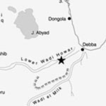
Fig. 1: Study area in the Sudanese desert (the star-signature marks the study-site; map: ForschungsstelleAfrika)
Study area
The WadiHowar is located in the North-west of the Sudan and traverses over a length of about 1000 km the southern margin of the Sahara between Jebel Marra in the West and the Nile Valley in the East. Once it was a tributary of the river Nile and joined it north-west of Ed Debba isohyets at 17° N and 31° N (Ritchie et al., 1985) and is part of the hyperarid core of the Eastern Sahara desert with partly less than 25 mm annual rainfall and a potential evaporation of 5–6 m (Petit-Maire&Guo, 1998,also Pachur&Kröpelin, 1987). Vegetation in the Eastern Sahara is very sparse and mainly confined to a few oases and to wadi channels, where single Tundub-bushes (Capparis decidua), acacia trees and transient communities of annuals and herbaceous perennials are present. The area of WadiHowar is mainly characterized by sedimentary rocks (Nubian sandstone), aeolian sediments, fluvial and lacustrine deposits. Partly volcanic (basalt), plutonic (granite) and metamorphic (quartzite) rocks were also found (Jas et al., 1988).
Material and Methods
Soil Survey and sampling
At the study location an intense survey of topographic units and potential interesting soil profiles was performed. Relic carbonate sediments and travertine were mapped. At the lowest point of the Wadi within the visual range of the fortress a 6m deep soil profile was digged and described according to the World Reference Base for Soil Resources (IUSS Working Group WRB 2007). Disturbed soil samples were taken from each horizon. The description and sampling in the field was completed by laboratory analysis of the soil samples.
Particle size distribution
Based on soil texture results from the field investigation and electrical conductivity 18 samples were selected and analysed for particle size distribution according to DIN ISO 11277 (2002). Humus destruction was not necessary due to low organic carbon concentration. Acid soluble carbonates were removed only in samples S09-12 (115-125 cm), S09-27 (525-580 cm) and S09-39 (600-620 cm). Sorting and mean size were calculated based on GRADISTAT Version 6.0 (Blott, 2008).
Organic and inorganic Carbon and Phosphorus
Total carbon (TC) of air-dried soil samples (< 2 mm), milled to < 63 µm, was determined with a CN-Analyzer(Vario EL III, Elementar, Hanau/Germany). To determine inorganic carbon (TIC) the samples were heated to 550° C for 6 h to destroy organic carbon before measurement. Organic carbon (TOC) was determined as the difference between TC and TIC.To determine total P concentrations, 10 ml of concentrated HNO3 (13 M) were added to 0.5 g soil and heated to 185° C for 20 min in a closed PTFE container. P concentrations were measured photometrically by a continuous flow analyzer (Skalar, Erkelenz) with a detection limit of 0.55 µM P, according to Murphy and Riley (1962).
14C-dating and 13C-measurement
Five charcoalsamples, part of a shrub brunch, eleven soil and three travertine samples were radiocarbon dated using accelerator mass spectrometry. The measurement was calibrated with INTCAL04 using the software CALIB5 according to Reimer et al. (2004). The 14C age was determined using oxalic acid (Ox I) as standard and δ13C was calculated relative tovPDB (IAEA). Travertine samples were measured without calibration.
Results
Soil profile
The soil profile showed a high amount of differently thick laminated fine grained sediments with a nearly horizontally laminated sand band in 375 cm depth below the ground level. Twelve single horizons were identified, which can be clustered into four different zones: (1) loamy sediments with dark layers (425-620 cm) (2) sandy sediments (375-425 cm), (3) loamy sediments with only one dark layer (300-375 cm) and (4) sediments with fissures (0-300 cm) (fig. 2). The sediments were characterized as (semi)-lacustrine, aeolian and colluvial sediments. The soil can be classified according to the World Reference Base for Soil Resources 2006 as Fluvisol (Yermic, Siltic).

Fig. 2
Profile 1, WadiHowar near Gala Abu Ahmed (cm below surface. Left side: photograph;
right side: position, shape and inclination ofsediment layers and position of desiccation cracks.
Particle size distribution
With the exception of a brief interval just below 375 cm, silt and clay-size particles dominate the total carbonate-free sediment. The main soil texture is loam. Most samples are very poorly sorted and very fine skewed. Mean size and sorting denote still water sedimentation (Stewart, 1958). Slow deposition in standing water typically showa mean particle size distribution between 2.5 and 6.5 ϕ (0.176-0.011 mm) and sorting between 1.0 and 3.1 ϕ (Stewart, 1958). Most of the samples from the studysite are in this range of still water sedimentation. Above 375 cm there are additionally indicators for anthropogenic activity like charcoal and increased phosphor content.
Mapping of Travertine
Travertine accretions were found and mapped in the area around the study site.
The accretions were concentrated near one contour line around the deepest point of the Wadi, ca. 20-25m above the Wadi ground (fig. 3).

Fig. 3: Distribution of travertine accretions (round marks) near the study site (star-mark). The overlaid lines mark the 5m-Isohypses. (Satellite image: WorldView-1, 2007, DigitalGlobe, Inc.)
14C age and stable carbon isotopes
The 14C age of soil carbon ranges from 4846 BC to 2039 BC. Charcoal was found in the depth between 40 and 275 cm and dated between 1490 and 2373 years BC. So, the 14C age of charcoal differs from the age of soil carbon (see table 1).

Table 1:14C-ages of organic matter and charcoal
The general trend in the 14C ages of soil organic C becoming older with depth is disturbed in the layers at 300 cm below surface, directly above the sandy layer, and near the calcareous bottom. Old 14C-ages were found at a close position near the ground surface (4000 BC). Measurement in the soil samples from 0 to 225 cm depth was not possible because of very low organic carbon content.All charcoal δ13C values besides of -45.8‰ (275 cm) and -21‰ (40 cm) are in the range of C3 land plants (Wiesenberg&Schwark, 2006). The extreme negative value like -45.8‰ is uncommon for charcoal, but possible as a result of participation of another CO2 source as atmospheric with higher δ13C values about -25‰ (Gebauer, personal communication). The δ13C values of various aquatic plants are often significantly more positive than those of terrestrial C3 plants and have sometimes been interpreted as indicators of the C4 photosynthetic pathway (O’Leary, 1981). The δ13C values of -9.8‰ to -.,7‰ near the bottom of the profile (580-600 cm) are very large, theδ13C values of soil carbon in the upper horizons (425-225 cm below surface) range between -29.7‰ to -35.2‰.
Discussion
The particle-size distribution and the lack of coarse particles and pebbles suggest lacustrine conditions and a standing water body during sedimentation. Due to its low density, charcoal transported by water would not sediment under conditions of high velocity of rivers. Thus, the charcoal could be an indicator for a lake or pool at the study site. The unsteady trend in 14C-age of soil carbon suggests a colluvial origin of the soil material. This would mean a period of higher vulnerability to erosion and less vegetation cover from 3400 years BC on. The thick layer of aeolian sand can be interpreted as an indicator for a dry period about 3700 years BC, followed by new lacustrine sedimentation. But as described by Mainguet (1982) aeolian sediments and their thickness are not a reliable indicator for a dry period. It cannot be suggested, that the aeolian sand transport even stopped during the hygric advantageous periods with vegetation which covered large areas. Caused by local factors an aeolian sand layer can be present in one profile and be absent in another only a few decametres away. This sediment layer is almost free of organic carbon, what alludes to a decreased vegetation cover, maybe as a result of climate change. Biological sterility, sedimentological and stratigraphical character speak in favour of episodic, at most weeks till months water-bearing pools as a result of heavy rainfall (Kröpelin, 1993). Such temporary lakes occur in the lowest elevation of a basin (Briere, 2000), are filled with water during rainy seasons or wet periods and usually become increasingly saline with evaporation and dry periods (Wetzel, 1975).
Charcoal was found in the upper layers < 300 cm below surface, starting with a 14C-age of 2373 BC and becoming younger near to the top. The youngest 14C-age is 1490 BC and so near the time range of the fortress. Taking the range of 14C-age of charcoal the mean sedimentation rate during this period was up to 0.38 cm pa, a higher sedimentation rate than the time before. Furthermore the P concentration in this layer is almost twice as high as below 275 cm. In general, the presence of charcoal can be interpreted as human activity close to the fortress since 2200 BC. The combination of a higher sedimentation rate and the deposition of colluvial soil material indicate changing environmental conditions, maybe influenced by human activity.
The unsteady 14C-age of soil carbon in different depths indicates that the organic matter of the measured layers probably dates from redeposited material of adjacent areas. The youngest sample is the travertine of the bottom of the soil profile (600->620 cm). Geyh (1983) describes the possibility of ion exchange and contamination of 14C ages with modern carbon of percolating water. So we suppose that travertine samples are contaminated with modern carbon making measurement unreliable. The latest age of charcoal is 1490 BC. So, at least periodically an open water body up to 1500 BC can be assumed. The detected travertine deposits at the wadi rim support this interpretation.
Carbon isotopic ratio results are useful to distinguish between aquatic and terrestrial plant sources of sedimentary organic matter and help identify organic matter from different types of land plants (Meyers, 1994). δ13C values of the soil samples are in the range of C3 land plants (Hakansson, 1985; Schidlowski, 1988; Meyers, 2003; Wiesenberg&Schwark, 2006). This photosynthetic pathway is used by almost all trees, shrubs, herbs, and cold-season grasses and sedges (Raven et al., 1999). The sample in the depth of 580-600 cm has δ13C value of -9,8‰, perhaps an indicator of metanogenesis which might be induced by low redox potential (Hakansson, 1985). Such values can also be the result of C4 plants, which show higher δ13C values between -9‰ and -14‰ (Schidlowski, 1988; Wiesenberg&Schwark, 2006). The C4 pathway is used mainly by desert and salt marsh plants and tropical grasses and gives C4 plants a competitive advantage at higher temperatures because of higher water-use efficiency and in low atmospheric CO2 conditions (Raven et al., 1999; Ehleringer&Cerling, 2002). The δ13C values of various aquatic plants are often significantly more positive than those of terrestrial C3 plants and have sometimes been interpreted as indicating the operation of the C4 photosynthetic pathway (O’Leary, 1981). So, these δ13C values can indicate C4 plants like grasses or water plants. Altogether the shift of δ13C towards more positive values in sediments can (1) result from input of allochthonous material brought by water derived from C4 terrestrial vegetation. Additionally, (2) an input of aquatic organic matter enriched in 13C (mainly in sediments) and (3) microbial methanogenesis leaving behind 13C-enriched organic matter can increase δ13C values (Hakansson, 1985). For methane formation anaerobic conditions are needed. It’s highest intensity is during periods of stagnation and during periods of high organic production in very eutrophic and shallow lakes (Hakansson, 1985; Schönborn, 2003). In our case the first and the third theory are most probable. Considering redox spots 425 cm below surface, these suggestions could indicate a former aquatic milieu. Consequently, roots found in the travertine at the 600-620 cm depth could belong to water plants like Chara (Kelts&Hsü, 1978).
Kröpelin (1993) and Pachur&Kröpelin (1987) assume that until around 2050 BC the Wadi itself was most likely a chain of permanent lakes and temporary pools that was only exposed to partial fluvial action after substantial local precipitation. They describe silty sandy material like those observed on the studied site as typical for not ground-water controlled Holocene drainless depressions (Kröpelin, 1993). The difference between our samples and true lake sediments is the presence of blow sand which could be interconnected as a layer and brought with water (Kröpelin, 1993) or even by wind during a dry phase. Furthermore, such siliceous deposits have a lack of fossils and less high concentration of carbonate and carbon (Kröpelin, 1993). Nowadays contour lines of the study area show a depression near the fortress that emphasizes the idea of a periodically water filled sink (compare fig. 3). However we cannot infer from current topography to ancient times. Laminated travertine found on the ground surface in higher positions is concentrated around one counter line, and may reflect higher water level of a paleolake (Hoelzmannet al., 2001). Carbonate crusts could indicate decreased water depths, translation to strandlines and/or seasonally flooded areas (Hoelzmann, 2001).
Conclusions
Near the fortress evidence of several changes in environmental conditions was found, e.g. an increase of erosion and deposition of colluvial sediments during the last millenia BC and a change of wet and dryer periods in combination with increasing human activity. Six metres of sediments were accumulated as a result of seasonal or periodical rainstorms connected with large-scale erosion. Over a long time span a small lake or a comparable open water source near the fortress is likely, at least periodically. A possible surface water source existed about 1500 BC. This conclusion is based on grain size distribution as well as lamination with organic accumulation, charcoal and travertine including plant remains on the profile bottom. Organic matter could be allochtonous and was transported with water or origin from surrounding vegetation, but also autochtonous and origin from water plants. Both possibilities point to humid climate conditions around the research area. Afterwards temperatures increased and the open water source was reduced due to evaporation. At the same time carbonate precipitated as a result of temperature increase and CO2 degassing photosynthesis of plants. This phenomenon might indicate a decrease in vegetation cover, a shallowing water body as well as a decrease of sand content in the samples. Final desiccation is indicated by the finely stratified sand layer in 375-425 cm below surface.
Due to charcoal the lacustrine sediments above 375 cm can be filed in a range between 2370 and 1490 BC. Whether this open water source still existed while the fortification was used is not clear. But due to the short time period between the youngest 14C-dates of the charcoal and the building of the fortification at least a sufficient groundwater reservoir and water supply on this spot during the use of the fortification is highly presumably. Finds of pottery prove that already in former times the WadiHowar was an important trading route from the Nile to the West. Establishing checkpoints at the water supplies along anexisting trade route would allow controlling the whole border line. This would give a strong reason for the maintenance of such a large fortification more than 100 km west of the River Nile at the borders of the Egyptian Empire.
Acknowledgements
This research was funded by Fritz-Thyssen-Fundation. Special thanks to Dr. Abdel Rasik (GRAS, Khartoum), Dr. Friederike Jesse (ForschungsstelleAfrika, Cologne), well workers and Karlo for enabling this project and field support, Sabine Rautenberg and Monika Rohrbeck (Department of Soil Science, TU Berlin), Dr.NadjaPöllath (Ludwig Maximilian Universität Munich), Christian Loeser (Bochum University of Applied Science), and Dr. Kromer (Heidelberg Academy of Sciences) for laboratory support and carbon isotope analysis, and DörteDosse (UNIMAK) for graphic works.
Nadia Prays
Helmholtz Centre for Environmental Research– UFZ, Halle, Germany
Friederike Lang
Albert-Ludwigs-Universität Freiburg, Germany
Martin Kaupenjohann
Technische Universität Berlin, Germany
Andreas Gundelwein
Deutsches Museum München, Germany
References
Briere, P. R., (2000). Playa, playa lake, sabkha: Proposed definitions for old terms. Journal Of Arid Environments, 45(1):1–7.
Ehleringer, J. R. and T.E. Cerling (2002).Encyclopedia of global environmental change, Volume 2, The Earth system: biological and ecological dimensions of global environmental change, chapter C3 and C4 Photosynthesis, page 186–190. egec.
Eigner, D. (2013). A Stone Building in the Desert Sands – Some Remarks on the Architecture of the Gala Abu Ahmed Fortress. In: Friederike Jesse & Carola Vogel (eds.), The Power of Walls – Fortifications in Ancient Northeastern Africa. Proceedings of the International Workshop held at the University of Cologne 4th-7th August 2011. Colloquium Africanum 5, Köln 2013: 309-319.
Hakansson, S. (1985). A review of various factors influencing the stable carbon isotope ratio of organic lake sediments by the change from glacial to postglacial environmental conditions. Quaternary Science Reviews, 4(2):135–146.
Hoelzmann, P., B. Keding, H. Berke, S. Kröpelin and H.-J.Kruse (2001).Environmental change and archaeology: lake evolution and human occupation in the eastern Sahara during the Holocene. Palaeogeography, Palaeoclimatology, Palaeoecology, 169(3-4):193–217.
IUSS Working Group WRB (2007). World Reference Base for Soil Resources 2006, first update 2007. World Soil Resources Reports No. 103. FAO, Rome.
Jas, C., H. Klitzsch, P.,Schandelmeier and P. Wycisk (1988).Geological map of NW-Sudan 1:1.000.000 El Atrun/NE 35. TechnischeFachhochschule Berlin.
Jesse, F. (2013).Far from the Nile – The Gala Abu Ahmed Fortress in Lower WadiHowar (Northern Sudan). In: Jesse, F. & C. Vogel (eds.), The Power of Walls – Fortifications in Ancient Northeastern Africa. Proceedings of the International Workshop held at the University of Cologne 4th-7th August 2011. Colloquium Africanum 5, Köln 2013: 321-352.
Kelts, K. and K. J. Hsü (1978).Lakes. Chemistry, Geology, Physics, chapter Freshwater carbonate sedimentation, pages 295–323. Springer Verlag.
Kröpelin, S. (1987).Paleoclimatic Evidence from Early to Mid-Holocene Playas in the Gilf-Kebir (South-West Egypt).Paleoecol. Africa 18, 1987, 189–208.
Kröpelin, S. (1993). Zur Rekonstruktion der spätquartären Umwelt am Unteren Wadi Howar (Südöstliche Sahara/Nordwest Sudan). Berliner Geogr. Abhandl.54 (Berlin 1993).
Kuper, R. and S. Kröpelin (2006). Climate-Controlled Holocene Occupation in the Sahara: Motor of Africa’s Evolution. Science 313, 2006, 803–806.
Mainguet, M. (1982).Lèpaisseur des depots sableuxeoliensest-elleunindicateurd’aridite? [Is the thickness of the sandy aeolian deposits a proof of aridity? Bulletin de l ’association de geographesfrancais, 59:64–68.
Meyers, P. A. (1994). Preservation of elemental and isotopic source identification of sedimentary organic matter. Chemical Geology, 114(3-4):289–302.
Meyers, P. A. (2003). Applications of organic geochemistry to paleolimnological reconstructions: a summary of examples from the Laurentian Great Lakes.
Murphy, J. and J. P. Riley (1962). A modified single solution method for the determination of phosphate in natural waters. AnalyticaChimicaActa 27, 1962, 31–36.
O’Leary, M. H. (1981).Carbon isotope fractionation in plants.Phytochemistry, 20(4):553–567.
Pachur, H.D. (1987). Vergessene Flüsse und Seen der Ostsahara. Geowiss.inunsererZeit 5, 2, 1987, 55–64.
Pachur, H.D. and S. Kröpelin (1987).WadiHowar: Paleoclimatic evidence from an extinct river system in the southeastern Sahara. Science 237, 1987, 298–300.
Petit-Maire, N. and Z. T. Guo (1998).Mid-Holocene climatic change and man in the present-day Sahara desert. In: A. S. Alsharhan, K. W. Glennie, G. L. Whittle and C. Kendall (eds.), Quaternary Deserts and Climatic Change (Rotterdam 1998) 351–356.
Raven, P., R.F. Event and S. Eichnorn (1999). Biology of plants. W.H. Freeman and Company, New York.
Ritchie, J.C., C. H. Eyles and C. V. Haynes (1985).Sediment and pollen evidence for an early to mid-Holocene humid period in the eastern Sahara. Nature 314, 1985, 352–355.
Schidlowski, M. (1988).A 3,800-million-year isotopic record of life from carbon in sedimentary rocks.Nature, 33(6171):313–318.
Schönborn, W. (2003). Lehrbuch der Limnologie. E. Schweizerbart’sche Verlagsbuchhandlung (Nägele u. Obermiller) Stuttgart.
Stewart, H. B. (1958). Sedimentary reflections of depositional environment in San Miguel Lagoon, Baja California, Mexico. AAPG Bulletin, 42(11):2567–2618.
Vernet, R. (1995). Les Paléoenvironments du nord de l’Afrique depuis 600 000 ans. CNRS Dossiers etRecherches sur l’Afrique 3, 1995, 149–271.
Wetzel, R. G. (1975): Limnology. W. B. Saunders Company, Philadelphia.
Wiesenberg, G. L. and L. Schwark (2006).Carboxylic acid distribution patterns of temperate C3 and C4 crops. Organic Geochemistry, 37(12):1973–1982.
![]()
Quest’opera è distribuita con Licenza Creative Commons Attribuzione – Non commerciale
Condividi allo stesso modo 4.0 Internazionale.
This work is licensed under a Creative Commons Attribution-NonCommercial- ShareAlike 4.0
International License


Leave a Reply