 In 2013 Mario Giorgetta, an academic botanist from Switzerland, discovered for the first time a small rock panel with a collection of clearly associated pictographs on a rock cliff in the gorge of the Río Vilama. Mario reported the site to me in 2019 and we agreed to publish a paper describing the panel and its context. This paper comprises two parts. The first part is written by Maarten van Hoek and briefly attempts at interpreting the elements that make up the pictograph scene and the second part is independently written by the discoverer of the pictograph panel at Guatin, Mario Giorgetta.
by Maarten van Hoek and Mario Giorgetta
*
New Pictographs at Guatin
Atacama Desert – Northern Chile
By Maarten van Hoek and Mario Giorgetta
*
Introduction
In 2013 Mario Giorgetta, an academic botanist from Switzerland, discovered for the first time a small rock panel with a collection of clearly associated pictographs on a rock cliff in the gorge of the Río Vilama. Mario reported the site to me in 2019 and we agreed to publish a paper describing the panel and its context. The site, named Guatin after the nearest village (located 4.5 km to the NE), is located just under 3000 m O.D. and 223 km inland, about 17 km NE of the village of San Pedro de Atacama in northern Chile. The coordinates in Google Earth (2020) are: 22°47’1.69″S and 68° 6’38.79″W.
This paper comprises two parts. The first part is written by Maarten van Hoek and briefly attempts at interpreting the elements that make up the pictograph scene and the second part is independently written by the discoverer of the pictograph panel at Guatin, Mario Giorgetta.
PART 1
The Guatin Panel and its Possible Meaning
By Maarten van Hoek
*
Description of the Area
The Río Vilama, that has some water flowing all year round, runs SW towards the Salar de (San Pedro de) Atacama in a rather deep gorge that is flanked by on both sides by a young and hard basaltic lava-flow (some 30.000 years old) from the Sairecabur volcano (about 24 km to the ENE of the Guatin Site and with its summit at 5970 m O.D.). This basalt-flow is on top of and surrounded by the more ancient, 3 million years old lava-ashes of the Llaño Pelón. Sairecabur is visible from (near) the site. About the same distance to the ESE is Licancabur, the Sacred Mountain of the region, but this volcano is invisible when observing the Guatin Panel (it is visible from the pampa). The basalt panel with the pictographs is found at the south bank and faces north across some ancient stone structures at the base of the cliff and across the gorge.
On the more flat and higher part immediately north of the gorge is an area with clearly visible camelid tracks running to the NE, also leading towards a point – about 650 m upstream – where the gorge could be crossed. At that point – but on the south side – there are some ruins of houses and a large low stone corral. It is possible that the llama-caravans were once observed from very near the rock art panel.
*
The Pictographs
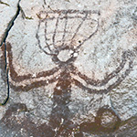
The NW facing panel (measuring roughly 40 by 30 cm), located rather high up the cliff, features a group of pictographs that has five elements that most likely are all associated and thus may compose a scene possibly conveying a specific message. All the five elements (Figure 1; see Figure 4 for a photo of the panel) seem to have been painted in the same white-yellowish colour (see however the remarks by Mario Giorgetta in Part 2), although Elements 3 and 4 and especially Element 5 are somewhat faded.
Click on any illustration to see an enlargement
Figure 1: The pictographs of Guatin, northern Chile. Drawing © by Maarten van Hoek, based on a photograph by Mario Giorgetta.
Element 1 comprises a complex, vertically orientated zigzag line with short, often curved appendages emerging from the curves of the central zigzag. From the lower end emerge two irregular meandering lines; the left line probably being unfinished. The top end ends in a roughly triangular yet open, outlined shape with two lines attached. Element 1 is 21.5 cm tall.
Element 2 comprises three rows of altogether 19 rather dynamically depicted anthropomorphic figures that apparently are dancing while holding hands. One figure in the top row is somewhat larger and has four appendages from the head. It seems to be the leader of the dance. It is the only ‘dancer’ with one drooping arm. This ‘leading’ anthropomorph is 7 cm tall; the smaller figures range from 4 to 6 cm in height.
Element 3 is a complex anthropomorphic figure with an outlined head with six appendages; three at each side of the rectangular head. This head is the only outlined element of the whole scene. It seems to have two eyes that may be connected to the sides by short stripes. There is no mouth or nose visible. Importantly, the almost fully frontally depicted figure has outstretched, curved arms and each hand seems to hold a camelid by the neck. The camelids look in opposite directions. The whole composition give the impression of the Andean Staff God. The lower part of Element 3 is somewhat problematic. The two triangular parts of the camelids may be regarded to represent the hind legs of the animal. However, only its right ‘leg’ seems to continue, ending in a human-looking leg plus foot (situated between two ‘dancers’ of the bottom row of ‘dancers’). The foot is shown in twisted perspective. It cannot be decided whether this ‘leg’ is superimposed upon the row of dancers, or that the ‘leg’ is superimposed by the row of dancers. Nonetheless, it is also possible that the anthropomorphic figure has no legs and is actually sitting on the rear ends of the two camelids. The figure measures 17.5 cm from the purported foot to appendages.
Element 4 comprise three small zoomorphic figures very near Element 3 that cannot be identified with certainty. They may represent camelids or dogs (foxes?).
Element 5 is a horizontally painted line that seems to end a curl (the left part is much weathered). It may represent an unfinished pictograph.
*
Parallels in Regional Rock Art
First of all it must be emphasised that – despite the fact the images are pictographs – the imagery has more parallels in the petroglyph art of the region: the area between the Salar de Atacama and the rock art site of Ariquilda. Mario Giorgetta suggests that the hard type of stone at the site was possibly the reason for painting the images, instead of carving.
Element 1 may represent a phytomorph and just possibly the meandering lines at its lower end represent its roots or perhaps water. At Tamentica (a major rock art site 230 km to the NNW of Guatin) there are some petroglyphs of phytomorphs that look like Element 1 at Guatin (Figure 2-1). At another major rock art site, Ariquilda (378 km NNW of Guatin), the petroglyph of a similar zigzag line is topped by a human-looking, outlined head with possibly ten short appendages (Figure 2-2). Also at Ariquilda are petroglyphs of similar phytomorphic elements, like on Panel ARQx-231 (Van Hoek 2017: Fig. 2) and Panel ARQx-207 (Van Hoek 2017: Fig. 3). At the petroglyph site of Chuzmisa (360 km NNW of Guatin) is a similar configuration without human or animal traits (Figure 2-3). Much further north and in a completely different cultural context is the petroglyph site of Miculla in southernmost Peru (582 km NNW of Guatin), where one scene involves an archer that seems to lead a row of dancers (the front one blowing a wind instrument), while the row is followed by a plant-like element.

Figure 2: A: Petroglyph at Tamentica, northern Chile; B: Petroglyph at Ariquilda, northern Chile; C: Petroglyph at Chusmiza, northern Chile. Drawings © by Maarten van Hoek, “C” based on a drawing by Paulina Chávez in: Vilches and Cabello (2011: Fig. 3.A-14).
At a rock art site in the upper reaches of the Río Loa (approximately 110 km NNW of Guatin) is a rock panel with the Ayquina Style pictographs of two laterally depicted anthropomorphs that are facing each other, while both are reaching with one arm/hand for a staff-like object. To the right of this scene is a phytomorphic pictograph that has much in common with Element 1 at Guatin. To the left of the scene are two more similar phytomorphs, but much fainter.
Also pictographs in the Cueva Blanca Style often have phytomorphic elements as well as anthropomorphs holding hands. In the Alto Salado area (about 53 km north of Guatin) the pictograph of an anthropomorph is enclosed by phytomorphic elements similar to the one at Guatin, while in the same drainage pictographs of anthropomorphs holding hands have been depicted. Pictographs of the Cueva Blanca Style depicting anthropomorphs holding hands (dancers?) have been recorded at a Río Salado site (approximately 53 km north of Guatin). However, in this case there is no association with a phytomorph.
Conclusion
Element 3 is the figure that truly dominates the scene due to its size and posture. Because of its specific pose and because the figure holds two camelids by the neck with outstretched arms, this figure is looking like the well-known Andean Staff God. It may therefore also be related to the Avian Staff Bearer, a petroglyph of which was once reported at the rock art site of Vilama in the same drainage, some 9 km downstream to the SW (Van Hoek 2016: Fig. 6). Because of the closely packed elements, the whole scene most likely involves some kind of fertility-ritual comprising a group of dancing (?) figures, a plant-like element and a dominating deity holding two camelids. In this way – so it seems – the fertility of plants, animals and of humans has been depicted in one scene.
*
PART 2
A Pictograph at Río Vilama
By Mario Giorgetta
San Pedro de Atacama was populated since prehistoric times by the Atacameños who spoke their own language “Kunza”. The settlement lays at 2450 m asl in desertic landscape at northern end of the Atacama-Depression, a geological basin without outlet forming thus the salt flat of Atacama in northern Chile (Figure 3). Formerly hunters, the Atacameños were living on cattle and crops in their extended oasis, supplied by the all year around flowing waters of Río San Pedro and Río Vilama. The long and narrow coastal desert of Atacama acts like a deadly barrier between the Pacific coast and the Andean hinterland to the east.
As San Pedro lays at the eastern edge of the desert it became an important stopover for the caravans crossing between the Pacific coast and the Andean highland or the lowland regions beyond to the east. The ancient trails were used for many centuries until the appearance of the motor-car and countless petroglyphs carved and pecked in canyon-walls and on boulders of volcanic rock are witness to different cultures at different times of the ancient peoples that used those trails.
The surroundings of San Pedro are dominated by wide lava fields, where young lava flows dating from the Pleistocene (20 kya and older) cover older volcanic ashes from the Pliocene (2.6–5.3 mya) when flowing from the Andean volcanoes towards the Atacama Depression. The longest of these young lava flows originates at the crest of the Andean Cordillera at almost 6000 m asl and descends to 2850 m asl, about 500 meters above the salt flat and San Pedro. The lava flows are dissected by deep-cut valleys and narrow gorges, some of them with running water, but none of the water flows permanently reaches the bottom of the Atacama Depression. While the surrounding volcanic ashes are deeply weathered, the lava flows consist of variously broken and fissured hard basaltic rocks.
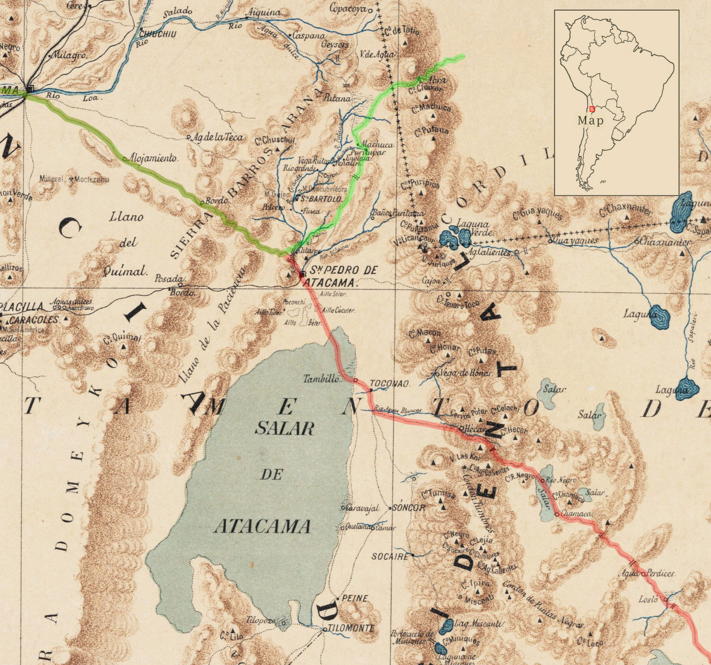
Figure 3. Map of the area around the Salar de Atacama. 1892 Carta Jeográfica del Desierto i Cordilleras de Atacama.
Carving pictures into rocks of volcanic ashes is easy, as the rock is of soft consistence. Furthermore the carved pictures appear in light grey color of the volcanic ash, while the surrounding surface contrasts in brownish shades by centuries of weathering. Older rock-art generally faces west to the setting sun while the younger sort (e.g. from the Inca era) faces towards the rising sun at the east. Carved or pecked pictures are found exclusively on old volcanic ashes; the young basaltic rock is far too hard for that purpose while rock paintings (pictographs) are very rare around the Atacama Depression.
One of those pictographs was found in a basaltic gorge at 3000 m asl some 17 km northeast of San Pedro, where the Vilama River is breaking through the above-mentioned young lava flow. Nearby are the ruins of some scattered basic stone-houses with corrals. Probably they were used to put out to graze lamas in autumn, when after summer rain-season the surrounding fields cover with fresh plants. On 27 of October 2013 I was looking for cacti vegetation in that canyon and wrote down in my notepad:
‑ Find here a strange, about 35cm small very interesting pictograph or rock painting showing twenty people holding hands and a graphically very sophisticated dignitary with two camelids in artistically high representation. It probably exist several more such images, will look for them occasionally. –
Neither the kind of paint used nor its original color can be established as it disappeared completely. However before painting, the surface of the rock probably was cleaned and the paint later on saved the covered surface from weathering again, resulting in the contrast we see at present. At the eastside of that canyon lays a small flat area with two big prehistoric roundhouses built with double stone-walls in the archaic Atacameños-style. Maybe the twenty people holding hands are reminiscent of feasting and dancing by the tribe at the roundhouses. The graphically brilliant portrait of the big dignitary united with two camelids and protecting further two below his arms may signify protection for the grazing cattle. This is the more obvious, as the last animal to the right with the long, hanging tail is the typical representation of the Andean fox, which in fact is more wolf than fox. There are two species living here: Lycalopex griseus and the bigger Lycalopex culpaeus (Canidae). Both are solitary hunters and particularly “el culpeo” may attack and kill sheep, goats and young lamas. To the left of the composition there is a vertical zigzagging figure whose meaning is not evident (see however Part 1). This figure continued further to the left, but there it was damaged and washed away by flowing rainwater.

Figure 4. The pictographs at Río Vilama. To the left, part of it was washed away by rainwater flowing down. Weathering of the surface of the basaltic rock occurs by temperature changes, hydration, oxidation, UV radiation and being covered with lichens. The original paint disappeared; however it slowed down weathering, thus producing the contrast as seen now (see as well Figure 6).
Among the considerable number of petroglyphs I recorded in this region during my fieldwork along the past forty years, this small pictograph is outstanding not only by the manufacturing technique and the grade of abstraction, but as well by being one of the very few showing people in a social context and not as single individuals. Considering the abstraction as well as human beings as the centre of attraction, I guess its age to be about 500-800 years before present.

Figure 5. Supposed sequence when drawing the composition with the protecting shepherd.
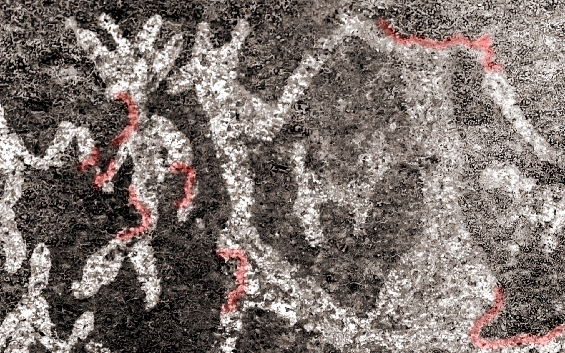
Figure 6. Weathering of surface. Red marked details show lichen growing slowly as well over paint-protected areas leading thus to distortion of the original picture.
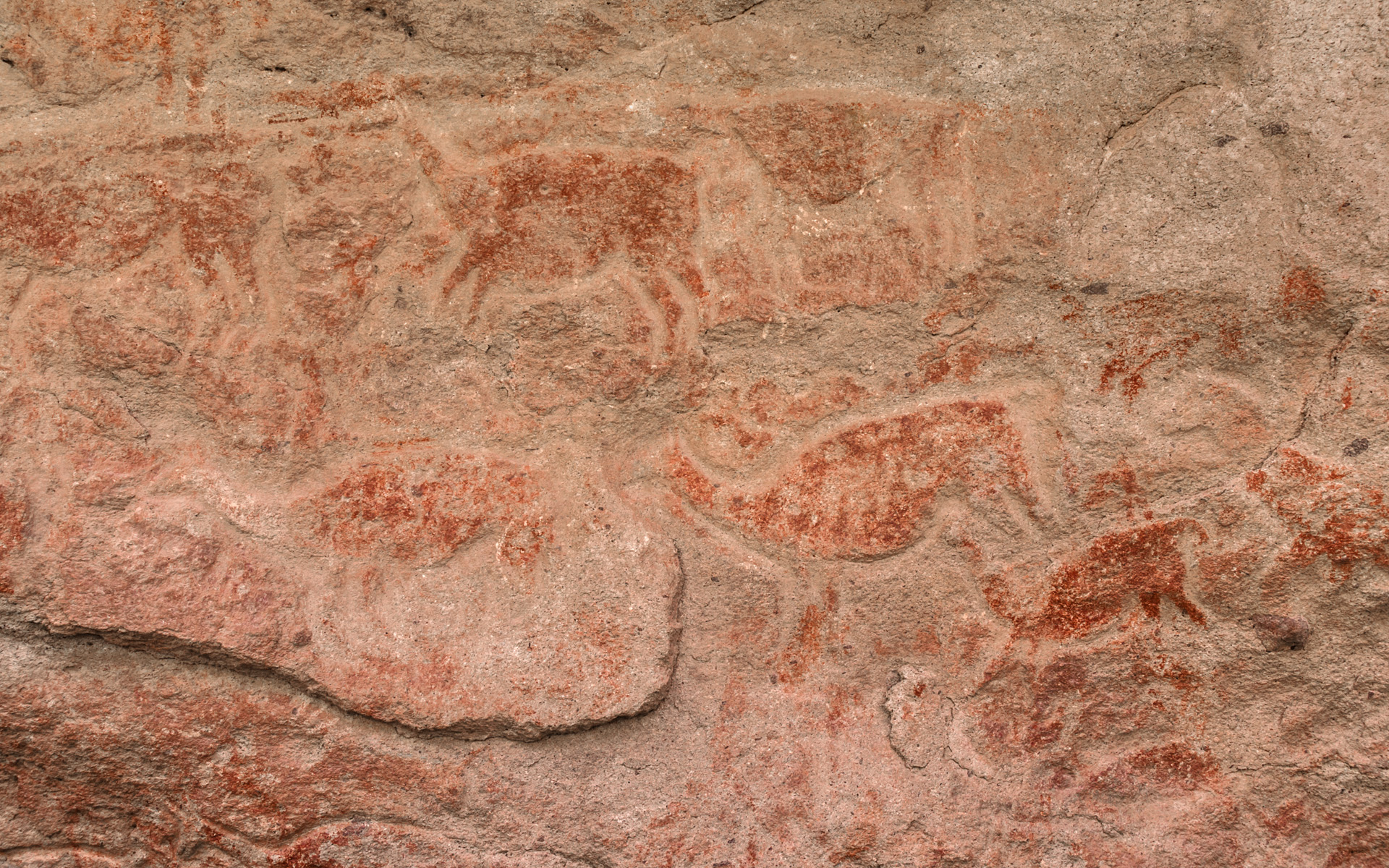
Figure 7. Use of paint on an archaic petroglyph in a cave nearby along Paso del Rey (see Figure 3). First a relief was made by carving the contours into the volcanic ash and then the animals were coloured. This scene with naturally depicted running prey (guanacos) decorates a burial site (chullpa) and belongs to the most ancient rock-art in this region

Figure 8. Guardian of a necropolis.
Near to the meeting point of Paso del Rey with the highland-trail (see next paragraph) lays well hidden among the rocks an extended burial place with several chullpas. The entrance to that necropolis is by a narrow crevice in the rocks, where a group of painted guardians protects and defends the souls of the deceased from bad spirits.
Painted pictures are more frequent at highlands as by the proximity of the volcanoes the consistence of the crystalline basaltic rocks often makes carving impossible. However, the technique of painting carved pictures occurs as well seen (see Figure 7). I took this picture 40 years ago exploring that region by military maps and fixing my positions by triangulation, as GPS at that time wasn’t yet available for civilian users.
This former Bolivian territory was conquered by Chile in the Salpeter War (1879-1884). Thereafter Chilean government mapped the new territory with an amazingly accurate 1892 edited map (detail above) showing all bridle paths and mountain trails along water holes and springs, rivers, animal feed and shelter for the night – important in this desert when people still moved on mules and horses. Supposedly same paths were used during centuries as many petroglyphs, graves, sacred places with votive offerings and shelters with corrals still line those trails. The red marked one joined the pacific coast to the Chaco region. Travelers in 19th century report that in order to cross the mountain-desert starting from Toconao (center of this map) it took seven days on horseback without human trace until reaching Los Molinos in Calchaquí-valleys (Salta, Argentina). Historically most important seems to be the green marked one, called El paso del Rey (the king’s trail) in colonial era and connecting the coast to the north-south running trail all over the highlands of ancient Andean civilizations. Even reliefs related to Tiwanaku-civilization are skirting this ancient trail. It did not enter the oasis of San Pedro but crossed the waters of Río San Pedro ten kilometres north at a site called Cuchabrache instead.
*
References
Van Hoek, M. 2016. The Avian Staff Bearer. Upgrading a Controversial Icon in Atacama Rock Art. In: TRACCE – On-Line Rock Art Bulletin, Italy.
Van Hoek, M. 2017. Petroglifos Únicos en Ariquilda, Chile. In: TRACCE – On-line Rock Art Bulletin, Italy.
Vilches, F. and G. Caballo. 2011. Variaciones sobre un mismo tema: el arte rupestre asociado al complejo Pica-Tarapacá, norte de Chile. Chungará. Revista de Antropología Chilena. Vol. 43-1; pp. 37 – 52. Arica, Chile.
*
Maarten van Hoek – Holland
rockart@home.nl – https://arte-rupestre3.webnode.nl/bibliography/
Mario Giorgetta – Switzerland
mario@giorgetta.ch – https://giorgetta.ch/arte_rupestre.htm


Leave a Reply